


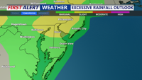
Delmarva faces an unsettled Sunday with showers and thunderstorms, some potentially severe with damaging winds and localized flash flooding. A warm front moves through ahead of a weak cold front Sunday night, followed by a hot and humid start to the week before a stronger midweek cold front brings relief heading into next weekend.
From
To

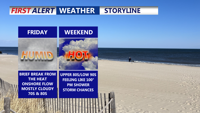
Delmarva’s weather pattern through the weekend and into next week will be dominated by a series of frontal boundaries bringing waves of warmth, humidity, and scattered thunderstorm chances. Friday begins cooler with cloud cover and a few showers, but a shift to a more southerly flow will increase temperatures through the weekend. The region could see highs in the 90s by early next week before another cold front arrives with a possible round of thunderstorms. Despite the unsettled pattern, extreme heat and widespread severe weather are not expected.

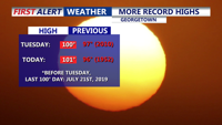
A second consecutive day of record-breaking heat on Delmarva peaked at 101 degrees in Georgetown on Wednesday, surpassing a decades-old high. The intense heat persists into Thursday with dangerous heat indices, but relief is in sight as a backdoor cold front ushers in cooler conditions and elevated storm chances heading into the weekend.

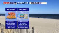
A strong high-pressure system building over the Mid-Atlantic will bring dangerously hot and humid conditions to Delmarva starting Monday. Heat index values are forecast to soar between 100 to 110 degrees through Tuesday, with only slight relief expected by midweek. Heat Advisories remain in effect, with an Extreme Heat Watch issued for parts of southern Delmarva. Rain chances and cooler temperatures return by late week.

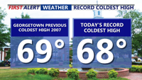
Father’s Day on Delmarva was one for the weather record books—Georgetown set a new daily cold high mark of 68°F, the third chilliest Father’s Day on record. Overcast and cool conditions linger through Monday with scattered drizzle and showers possible. A slow transition to a warmer and stormier pattern begins Tuesday, peaking Thursday with near-record heat and a risk of severe storms. Cooler, more settled weather returns for Friday and the weekend.

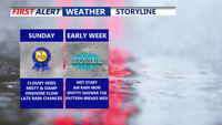
Clouds, cool temperatures, and the chance of scattered showers will dominate Delmarva’s Father’s Day forecast as a stalled front lingers near the region. Unsettled conditions will continue into early next week before a midweek warm-up sets the stage for possible severe storms Thursday. A return to sunny, dry weather is expected by Friday.


Delmarva endured a cloudy and damp Saturday with a mix of showers and hazy skies due to wildfire smoke drifting from New Jersey. The pattern of unsettled weather is expected to continue into Father’s Day and early next week, with cooler-than-normal temperatures, patchy fog, and occasional rain. A brief warm-up midweek could bring strong storms before relief arrives next weekend.

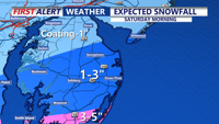
Light to moderate snow will taper off by midday, leaving accumulations of 1-3 inches across Sussex County, Ocean City, Salisbury, and the Eastern Shore, with up to 5 inches in Accomack County. Southern Delmarva will see the heaviest totals. Afternoon highs will reach the mid-30s with gusty winds. Black ice and slick spots are expected overnight as temperatures dip into the upper teens to low 20s. A sunny, milder stretch begins Sunday.

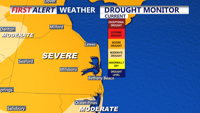
A passing cold front on Friday may bring a few isolated sprinkles to Delmarva, but the drought will continue as rainfall totals remain minimal. Breezy conditions will accompany the front, with drier and cooler air moving in by evening.