


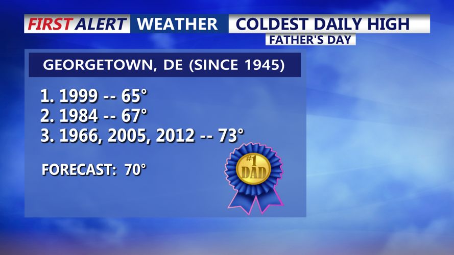
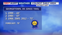


DELMARVA -- Father’s Day will feel more like early spring than summer across Delmarva, as clouds, drizzle, and a stubborn frontal boundary keep the region cool and damp through the remainder of the weekend. In fact we could possible crack the top 3 "coldest high" temperatures for Father's Day in Georgetown. Here's a look at the top 3.

Could crack the top 3 coldest high temperatures for Father's Day in Georgetown.
Hazy skies will continue all thanks to the Mines Sprung Wildfire burning in Wharton State Forest in Shamong Township, New Jersey. Air Quality Alert continues through 12AM Monday. Air quality will be unhealthy for sensitive groups.

Air Quality Alert for all of Delaware until 12AM Monday.
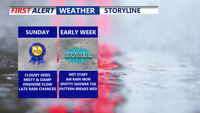
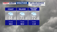
A stationary front remains positioned near the Chesapeake Bay and will continue to influence the weather through Tuesday. As a result, Sunday's highs will top out in the 60s to low 70s, with increasing chances for showers — particularly late in the evening — as a weak low pressure system rides along the boundary.

Overcast skies and a persist east to northeast wind will keep temperatures below average.
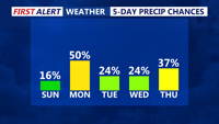
Will see rain chances Sunday night and Monday between 20 to 40 percent, with the possibility of isolated thunderstorms, especially across southern portions of the peninsula. Will remain under the influence of passing disturbances and damp air.

We keep rain chances in play at least for the next 5 days, each day won't be a complete washout.
Clouds will remain the dominant feature in the sky through Tuesday, with highs gradually climbing into the 70s. Lows will hold steady in the 60s. While the week won't be a total washout, rain chances will persist, interspersed with dry stretches. Expect limited sunshine throughout the early part of the week.
By Tuesday night, the stagnant front will lift north as a warm front, ushering in warmer and more humid air across Delmarva. Wednesday marks the start of a significant warm-up, with the region entering the "warm sector" of the approaching weather system.
This sets the stage for Thursday, which forecasters are eyeing for potential strong to severe thunderstorms. A cold front, coupled with an upper-level trough, will sweep across the Mid-Atlantic late Thursday. Delmarva could be a target for severe weather, including heavy rain, gusty winds, and possibly hail. More to come as the week progresses.
High temperatures Thursday could exceed 90 degrees, with heat indices in some areas topping 95. If these conditions materialize, heat alerts may be issued for the first time this season.
Thankfully, relief is in sight by Friday, as high pressure builds in behind the cold front. Sunshine and drier weather are expected to close out the week and continue into the weekend.