


High pressure will keep the region dry from early Friday through Saturday morning, with warmer inland temperatures and cooler conditions near the coast.
From
To

High pressure will keep the region dry and mild late Thursday night before warmer temperatures arrive Friday.


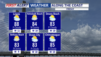
Delmarva will see a dry and gradually warming forecast beginning today, with inland temperatures in the 70s and cooler conditions along the coast. A high risk for dangerous rip currents continues from Delaware beaches south to Ocean City and Chincoteague. High pressure keeps the region dry through the end of the week, with some locations potentially reaching the low 90s by Friday and Saturday.

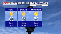
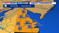
Delmarva stays sunny, dry, and breezy today with highs in the low 70s inland and upper 60s along the coast. A high risk of rip currents remains in place, with northeast winds gusting up to 25 mph and waves of 3 to 5 feet.

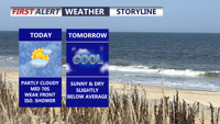
Delmarva will see a partly cloudy and breezy day today as a weak cold front and a back door cold front move through the region. A few isolated light showers are possible, mainly across Maryland and Virginia, but most areas will stay dry. Temperatures turn chilly tonight before a dry and gradually warmer pattern takes over through the end of the week.


A cold, clear night sets the stage for a sunny and seasonable Thursday before a warm front begins lifting through the region Friday night into the weekend.

Delmarva is set to enjoy a sunny and breezy Sunday with temperatures in the upper 60s to low 70s, feeling distinctly autumnal with low humidity. As the week progresses, a warming trend will take hold, with temperatures climbing into the 80s by midweek under mostly clear skies. High pressure will dominate, keeping conditions dry and pleasant through Friday, with a slight chance of rain developing by the weekend.