


Cooler air settles in for the end of the week with mostly dry, breezy days and cold, clear nights that may bring patchy frost inland.
From
To

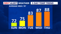
Sunday afternoon brings sunshine, cool temperatures, and breezy west winds across Delmarva. High pressure will dominate the region into midweek, leading to gradually warmer days and a potential return of summer heat by Thursday.

Sunday brings a refreshing start to June on Delmarva, with dry conditions, cool temperatures, and a light breeze. High pressure will dominate the region through midweek, setting the stage for a warming trend that could bring the first 90-degree day of the year by Thursday.

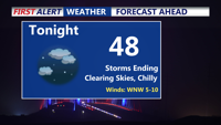
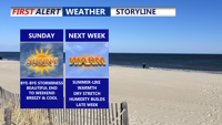
Storms have come to an end, clear and chilly night on tap as some areas away from the coast fall into the 40s. Bright, beautiful, breezy end to the weekend, summer-like next week as we make a run at our first 90 degree day of the year.

Delmarva will enjoy sunny skies and seasonable temperatures through the early part of the week, with high pressure dominating the weather pattern. Changes arrive midweek as a frontal system brings rain and possibly a few thunderstorms by Wednesday night into Thursday. Cooler and unsettled weather will follow through the end of the week.

Delmarva will experience one more unseasonably warm day on Thursday, with temperatures soaring into the 70s before a cold front ushers in cooler, drier air by Thursday evening and into early Friday morning.

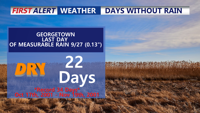
A prolonged dry spell continues across Delmarva as a warming trend sets in through the weekend and early next week. Today temperatures will reach the mid-to-upper 70s under clear skies, with slightly higher humidity. By early next week, temperatures could approach near-record highs in the low 80s, though coastal areas may remain cooler. While a cold front midweek brings a brief cooldown, significant rainfall remains unlikely, extending the already notable dry streak.