


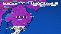
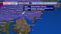
A Blizzard Warning continues for Sussex county and the rest of Delmarva until Monday evening.
From
To

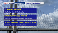
High pressure slipping offshore sets up a south to southwest breeze, kicking off a stretch of above-normal temperatures across Delmarva. A warm front Wednesday could bring a few late-day showers and push highs near 60°, followed by a possible backdoor cold front that may split the region Thursday into Friday. Another system brings a better chance of rain Friday into Saturday, and there’s early, uncertain potential for a more impactful storm later this weekend—possibly including snow—depending on track and available cold air.

Patchy freezing drizzle or a brief wintry mix early Wednesday may create isolated slick spots, followed by a colder stretch with a renewed refreeze risk Wednesday night into early Thursday.

A brief window for freezing drizzle late Tuesday night into early Wednesday could create isolated slick spots in Sussex County, especially on bridges and untreated roads.

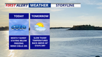
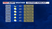
Delmarva remains well below average today (Monday) under mostly sunny skies, just a day after Georgetown set a record for the coldest “warmest” part of the day: a high of 20° on Sunday (Feb. 8), breaking the old record of 27° from 2007. Highs today range from 25–33° with easing winds. Clouds increase tonight as lows fall into the teens to low 20s. A warm front lifts through Tuesday, bringing a short-lived thaw with highs in the low to mid 40s.


A snowy morning in coastal Delaware did not last long in Lewes. By midday, fresh flakes turned into a wintry mix, and by nightfall, it was flat-out pouring rain.

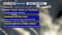
Delmarva gets a brief break with sun and milder temperatures through Thursday, but an arctic blast late Friday and a potential Saturday night-to-Monday storm could bring dangerous wind chills and significant snow.

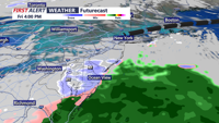
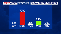
A fast moving system will bring a cold rain to our region with tricky travel farther north with ice and snow.

Delmarva stays sunny and seasonably cold today before a gusty cold front Thursday and a possible light wintry system Friday night into Saturday. More cold weather continues into early next week.

Delmarva will experience a series of weather changes this week beginning Saturday night, as a cold front ushers in chilly overnight lows. High pressure brings brief clearing Sunday, followed by multiple low-pressure systems bringing rounds of rain through midweek. A gradual warm-up returns by the weekend.