


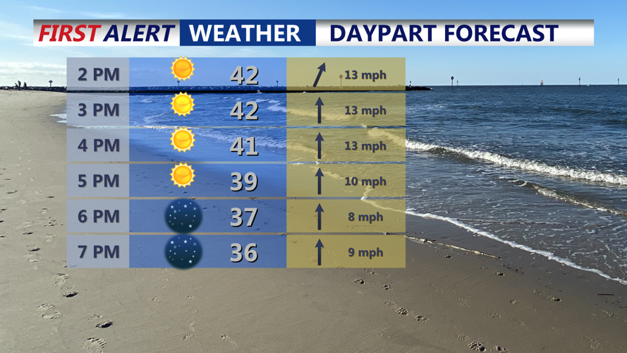


DELMARVA -- Today brings mostly sunny skies across Delmarva with seasonable highs in the low to mid 40s and gusty south winds that could reach around 30 mph in spots.

Sunny and seasonable, highs in the low to mid 40s, winds out of the south gusting to 30 mph.
Conditions turn a bit more unsettled tonight as a weak clipper system moves through, with lows falling into the low to mid 30s and a small chance of a brief shower under partly to mostly cloudy skies.

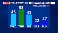
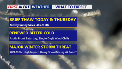
Seasonable day today, slightly milder Thursday ahead of another arctic front sent to move in Friday night.
Thursday is the pick of the week, looks like the mildest day of the stretch, with mostly sunny skies and highs climbing into the low 50s for many communities.
Clouds will increase Friday, a transition day. Skies stay mostly cloudy with highs generally in the upper 30s to low 40s, then an arctic front arrives late Friday night. A quick-hitting snow shower is possible as colder air pours in during the evening.
As we head into the weekend it turns brutally cold, with highs in the low 20s and wind chills dropping into the single digits in many areas. Forecast guidance also supports a prolonged stretch of very cold temperatures behind the front, with wind chills capable of turning dangerous, especially if snow cover develops.

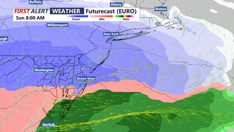
A major winter storm will impact the region Sunday-Monday, still some questions as to the overall track of the storm.
Confidence is increasing that a significant winter storm could affect Delmarva beginning Saturday night and potentially lasting into Monday morning. The latest outlooks indicate snow is likely to develop overnight Saturday into Sunday morning, with snow continuing Sunday and possibly falling heavy at times while northeast winds strengthen near the coast. There is still uncertainty in the storm track, which will determine where the heaviest totals set up and whether any locations briefly mix with sleet or freezing rain late Sunday—particularly closer to the coast—before turning back to snow Sunday night into Monday as precipitation tapers off.

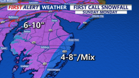
First projects of snow show 4-8" at the beaches, with some mixing to sleet/freezing rain possible, further inland totals could exceed a foot.
The snow won't be going anywhere next week as we stay brutally cold into next week with highs in the 20s, overnight lows in the single digits and wind chills nearing subzero.
Stay up to date on the approaching winter storm with radar and hourly forecasts in the CoastTV weather app, available for Apple and Android.
Manténgase informado sobre la tormenta invernal que se acerca a nuestra área con la aplicación del tiempo de Telemundo Delmarva, disponible para Apple y Android.
