


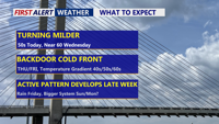


DELMARVA -- Turning noticeably milder today as high pressure moves offshore and winds shift to the south/southwest. That “return flow” helps pull warmer air into the region, setting up a warm air advection pattern.

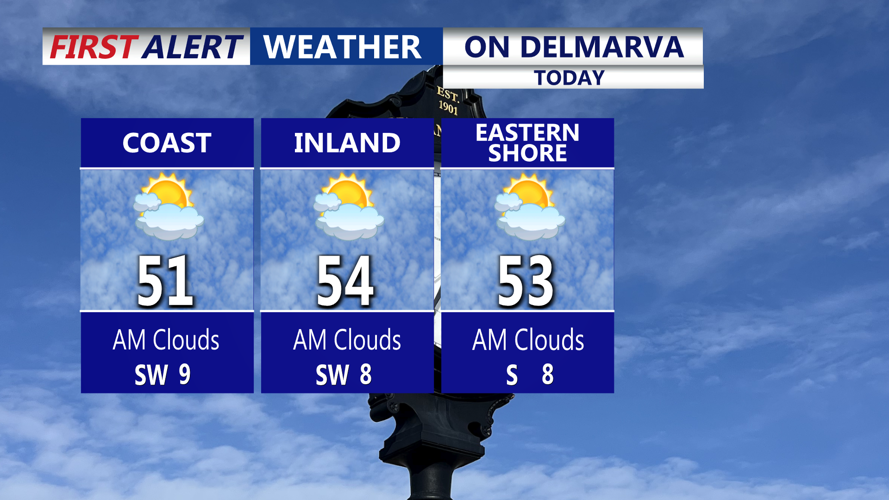
Partly cloudy skies through the afternoon, highs in the low 50s.
Expect partly cloudy skies today, with afternoon highs ranging from the upper 40s to the low/mid 50s across Delmarva. Tonight turns mostly cloudy, but temperatures should remain above freezing, generally in the upper 30s to low 40s.
Looking ahead, the mild theme continues as several weather systems line up to move through the Mid-Atlantic. The first key player is a warm front lifting through Wednesday. That should boost temperatures significantly, with many spots on Delmarva pushing into the mid to upper 50s to near 60°, especially where the warm sector sets up. While most of Wednesday looks dry, a few isolated showers could develop late in the day as the front passes.
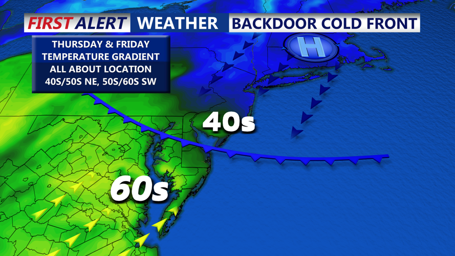
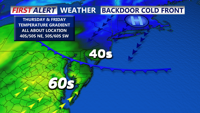
From there, forecast confidence drops a bit because some guidance suggests the warm front could lift north, then slide back south as a backdoor cold front—a cooler, maritime push driven by high pressure to the north and a north/northeasterly wind. If that front sets up across the area, it may bisect Delmarva, creating a noticeable temperature contrast from north/east to south/west.

There could be a temperature gradient on Delmarva Thursday and Friday thanks to a backdoor cold front.
Even where cooler air wins out, temperatures still look near or slightly above normal for this time of year. South of the boundary Thursday and Friday, highs are likely in the upper 40s to low/mid 50s, with the warmest readings potentially reaching the 50s to near 60 in the southwestern part of the region—depending on where that front stalls.

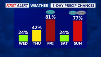
Rain chances increase Friday, a more significant storm system is possible Sunday-Monday.
Later in the week, another low pressure system approaches for the Friday into Saturday window. Right now, this appears to be primarily a rain event for most of Delmarva, and the timing lines up with the best opportunity for more widespread precipitation. That’s good news, since parts of the region remain in varying levels of drought, and this rain would be mostly beneficial.
Finally, there’s a late weekend system that has the highest potential—of the upcoming waves—to produce rain, snow and bigger impacts, but it’s still several days out and highly track-dependent. Ensemble guidance does hint at measurable snow in some scenarios, but outcomes range from an impactful storm to a complete miss. Stay tuned!
