


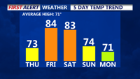


DELMARVA- High pressure to our north this afternoon is bringing an onshore flow to Delmarva, meaning generally dry and cooler conditions. With a flow off the ocean, humidity levels rise a bit, lowering the fire danger temporarily. Skies will be partly cloudy to mostly cloudy, with highs will be in the 60s at the beaches, with low to mid 70s for inland spots.
Thursday night is looking dry with partly cloudy skies, with temperatures in the 60s for lows.
Friday is looking partly cloudy and warm with highs in the 80s, cooler 70s at the coast. Watch for some isolated showers and thunderstorms into Friday evening.
Any shower or storm activity will end Friday evening, then partly cloudy skies with lows in the 60s.
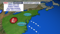
Heading into the weekend, Saturday is shaping up to be a warm and muggy day, with highs in the low to mid 80s. Cooler at the beaches. It will feel warmer with the muggy conditions. Saturday night will be mild and muggy with dry conditions and lows in the 60s. On Sunday a cold front will get closer to Delmarva, meaning a better chance for measurable rain. Temperatures will be cooler with highs in the 70s.
A cut off area of low pressure will develop to our west keeping rain chances going into the early to middle part of next week. Temperatures will be in the 70s with lows in the 50s.