


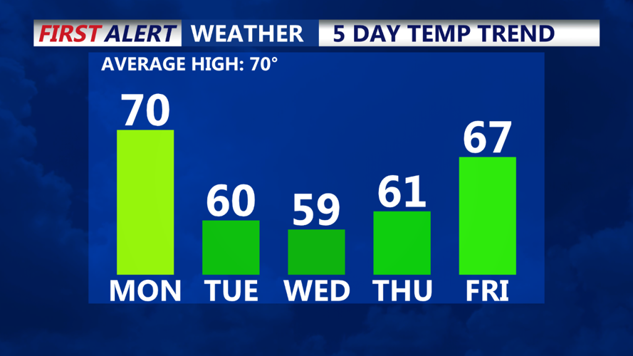


DELMARVA - A cold front moving through Delmarva is ushering in the coldest air of the fall season so far. Patchy frost is possible later in the week.
As a cold front pushes through Delmarva, we'll see winds getting gusty from the west-northwest this afternoon. Gusts will exceed 30 mph at times. Temperatures will be in the 60s and 70s, then start to fall through the afternoon as the colder air moves in. A mix of sun and clouds will be the rule, as it will definitely feel like fall later today.
This evening temperatures will drop quickly after sunset, with overnight lows near 40 inland, with mid to upper 40s at the coast. Winds remain gusty early, then diminish later. Skies will be partly cloudy overnight.
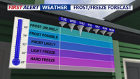
Tuesday morning will start off chilly, with temperatures in the 40s. A touch of frost is possible well inland. Conditions will remain dry with a mix of sun and clouds throughout the day. High temperatures will struggle to reach 60, with most areas in the 50s, and feeling colder with the wind.
Tuesday night into Wednesday morning we'll see some areas dipping into the upper 30s, with 40s elsewhere. Some patchy frost is possible for areas west of highway 113. Cover or bring in your tender plants just in case.

Wednesday will be another chilly day with mostly sunny skies and highs in the mid to upper 50s.

Wednesday night into Thursday morning is when we have the best chance for seeing frost. Lows will be in the upper 30s and 40s. You'll want to protect your tender plants at this time too.