Humidity crashes

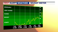
DELMARVA -- A refreshing change in the weather is on tap for Delmarva this afternoon, as temperatures drop into the 70s across the region, accompanied by a crisp and cool September-like feel. Winds will be a bit breezy, occasionally gusting over 20 mph, adding a noticeable chill to the air.

Rip current risk is MODERATE, waves 2-3 feet, so we aren't in the HIGH level like the past few days. Continue to use caution while in the ocean and always swim near lifeguards. 

As high pressure begins to move in from the northwest tonight, tranquil conditions will prevail. Dew points are falling into the upper 40s to 50s, very dry and comfortable. Expect clear skies and light winds, which will allow temperatures to dip into the 50s for most areas, while the coast is closer to 60 degrees.

Wednesday will feature continued sunshine with highs in the mid to upper 70s with overnight lows once again dipping into the mid 50s. Thursday look for mostly sunny skies and highs in the upper 70 to low 80s across the peninsula. 

Looking ahead to the weekend, high pressure will settle directly over Delmarva on Friday, bringing plenty of sunshine and warmer temperatures, with highs reaching the low 80s. Despite the warmth, dew points will remain comfortably in the 50s, making for a pleasant late summer day. Friday night will be milder, with lows in the 50s and low 60s.

As high pressure shifts offshore on Saturday, a southerly flow will bring even warmer air into the region. Highs will rise a few more degrees, and dew points will begin to creep back towards 60, though conditions will still be comfortable. Expect dry weather with increasing cloud cover compared to Friday. Nighttime lows will also trend warmer, with 60s becoming more common.

By Sunday, the southwesterly flow will continue, pushing highs into the mid to upper 80s and bringing in more humid air. While it won’t be as comfortable as the previous days, sunshine will still dominate the skies. However, some uncertainty remains for Sunday night and Monday, as a frontal boundary approaches from the northwest. While the possibility of showers is still uncertain, it’s something to watch as we head into the start of next week.  We could see the return to 90 degree temperatures by Monday. 


Meteorologist

Chris Mastrobuono is a South Philly native, but has come to join the CoastTV meteorology team. With over three years of experience delivering accurate, passionate and insightful weather analysis, he is eager to report on the coast. Previously, he spent over two years as a morning meteorologist at WEVV CBS/FOX in Evansville, Indiana. 

Recommended for you