


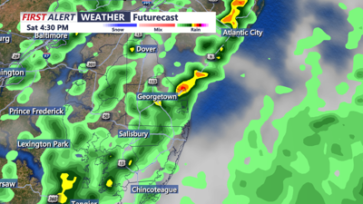
DELMARVA -- Expect a mostly cloudy start today, with dry conditions initially before rain showers begin to develop. The rain will be associated with a cold front that is expected to push into the northwestern parts of the area between 9 and 11 AM, reaching the I-95 corridor by around 2 PM, and moving into Delmarva between 2 PM - 3 PM offshore. Along the front, a few more robust cells could develop, potentially bringing brief heavy rain, a rumble of thunder, and wind gusts between 30-40 mph. In the wake of the front, scattered showers or a more widespread light rain is expected from west to east, with a likelihood of precipitation 50%. Rainfall totals will generally be light, between 0.1 to 0.25 inches. This is a relatively light and quick moving event.
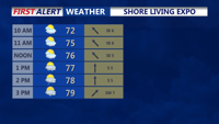
If you're heading out to the Shore Living Expo in Salisbury today be sure to say hello to yours truly and other COAST TV News personalities!

Temperatures on Saturday will be influenced by the timing of the front, with highs ranging from the low to mid-70s at the coast to the upper 70s to near 80 degrees across some inland locations. Winds will be southerly ahead of the front at 10-15 mph, shifting to the northwest with gusts of 20-25 mph behind the front.
Showers and any thunderstorms will taper off early Saturday evening as the cold front moves offshore. A deep upper trough will settle over the Northeast and Mid-Atlantic for the start of the new week, bringing cooler temperatures with lows in the 40s to low 50s on both Saturday and Sunday nights, and highs only reaching the upper 60s at the coast to low 70s inland on Sunday. By Monday, temperatures will moderate closer to normal, with highs climbing back into the upper 70s to near 80 degrees.

Looking further ahead, surface high pressure will dominate over the Mid-Atlantic from Monday night into Friday. The upper-level pattern will flatten out on Tuesday, with zonal flow aloft prevailing midweek and upper ridging developing by the end of the week. This setup will bring partly to mostly sunny skies and a warming trend, with temperatures rising into the mid to upper 80s through the week. While these highs will be 5 to 10 degrees above normal, they are not expected to reach record levels. Humidity will remain comfortable for most of the week, with dew points generally in the 50s, creeping up to near 60 by the week's end.
Overall, after a cooler and unsettled weekend, Delmarva will enjoy a stretch of warm, pleasant weather through the upcoming week.
MODERATE risk of rip currents through the weekend.