


DELMARVA -- Waking up to cloudy skies and the potential for scattered showers and thunderstorms as moisture builds ahead of an approaching cold front. A brief lull in activity is possible late morning into early afternoon, but don’t expect it to last. Dew points will rise into the low to mid-70s, making for a muggy start to the day.
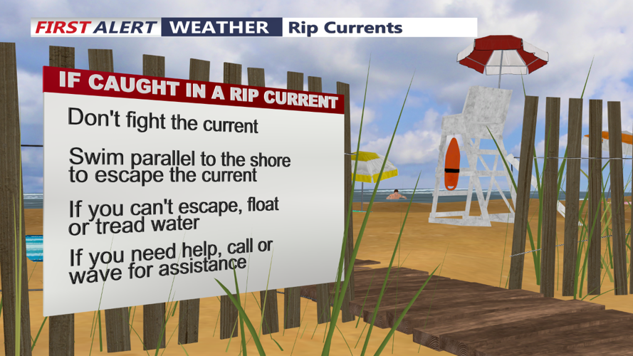
HIGH RISK OF RIP CURRENTS CONTINUES...Be mindful will continue to see dangerous rip currents from Hurricane Ernesto. In addition 3-6 foot waves and beach erosion. Pay close attention to the direction of lifeguards and never swim on unguarded beaches.

Look for the main event of storms to arrive in the early to mid-afternoon as a cold front begins its trek eastward across the region. At this time, an upper-level trough will dig into the area, increasing baroclinic forcing along the front and enhancing the potential for widespread heavy rainfall and strong thunderstorms.
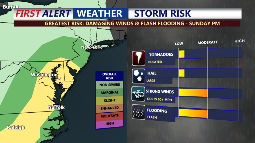
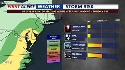
Though daytime heating will be limited, there remains some uncertainty about whether breaks in the clouds could occur. If any sunshine does break through, instability could rise, increasing the potential for severe thunderstorms. The Storm Prediction Center has placed Delmarva under a Slight Risk (2 out of 5) for severe weather, damaging winds is the primary threat, however an isolated tornado can’t be ruled out, in addition some hail. Stay weather aware this afternoon-evening. High temperatures will reach the mid 80s, but with the high humidity, it will feel warmer.
Heavy showers and strong storms will likely persist into the evening hours, gradually moving offshore after midnight. Flooding and severe risks will remain until the storms clear out. Overnight lows will drop to the mid-60s to around 70.
On Monday, the cold front that moved through on Sunday will stall near the coast, keeping the chance for showers and thunderstorms in the forecast. A secondary boundary is expected to move across Delmarva later in the day, bringing another round of storms in the afternoon and evening. This front will help push the initial boundary farther offshore, leading to slightly cooler and less humid conditions by Monday night. Highs will be in the upper 70s to low 80s.
Tuesday will feature one last push of cooler air as a final boundary moves through the region. A taste of fall arrives to Delmarva with highs only reaching the mid-70s and overnight lows in the 50s. Look for dry and calm conditions to extend into next weekend.