


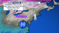


DELMARVA -- A bitterly cold start to the week as an arctic high-pressure system builds into the region. Temperatures will plunge into the single digits to lower teens tonight, with wind chills dropping to near zero by Tuesday morning. The National Weather Service has issued a Cold Weather Advisory for the entire region through Wednesday morning.

Single digit to teens feel-like temperatures.
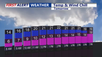
Tuesday will bring little relief, as high temperatures are expected to reach only the teens and low 20s, marking one of the coldest days of the season. Winds from the west at 5 to 10 mph will keep wind chills in the single digits and teens throughout the day. A mix of sun and clouds is forecast for the morning, but high clouds moving in from the south will filter much of the sunlight by afternoon.
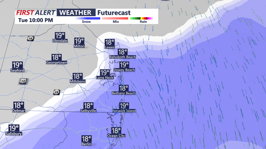
An upper-level trough moving into the region late Tuesday into Wednesday morning could bring a chance of flurries or light snow along the Delaware coast and Ocean City, though no significant accumulations are anticipated.

Flurries, period of light snow possible along the coast Tuesday night.
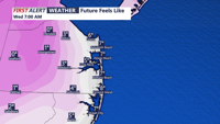
The coldest conditions are expected early Wednesday morning, with wind chills potentially falling as low as 5 below zero. Highs Wednesday will be in the upper teens to low 20s under partly cloudy skies.

Wind chill values 0 to -5 are possible Wednesday Morning
High pressure will dominate the region through midweek, keeping conditions dry but exceptionally cold. Temperatures will start to improve slightly by Thursday, with highs in the mid to upper30s. A gradual warming trend is expected to continue into the weekend, providing some much-needed relief.
Looking ahead, a low-pressure system could bring a slight chance of snow to parts of the region Thursday night into Friday morning, though confidence in this forecast remains low. The weekend appears mostly dry, with the potential for rain or snow showers late Sunday as a cold front approaches.
You can take precautions against the frigid temperatures, especially during the early morning hours when wind chills are at their lowest. Pets and vulnerable individuals should be kept warm as the region endures this arctic blast.