


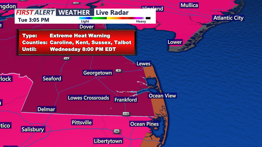

DELMARVA - Sussex County remains under an Excessive Heat Warning through late Wednesday as dangerously high temperatures and stifling humidity continue to grip the region. Tuesday’s heat is forecast to be even more intense than Monday’s, with temperatures rising 1 to 2 degrees higher in many locations.
Although slightly lower humidity may offer limited relief, heat index values—factoring in both temperature and humidity—are expected to mirror Monday’s levels, reaching well into the triple digits. A weak sea breeze will provide only minimal cooling along coastal areas and will not penetrate far inland.
The National Weather Service warns this extended period of heat is especially dangerous, with overnight lows staying in the mid-70s to around 80 degrees, leaving little time for the body to recover. In some urban areas, nighttime temperatures could be the warmest in more than a decade.
Extreme Heat Warnings are in place for most of the region, excluding immediate coastal zones where Heat Advisories remain. Health officials urge residents to stay indoors during the hottest parts of the day, drink plenty of water, and avoid strenuous activity. Never leave children or pets inside a parked car.
By Wednesday night, a cold front will begin approaching from the north, bringing a 20 to 40 percent chance of scattered showers and thunderstorms. Any stronger storms may produce gusty winds, but the risk of severe weather is limited.
Relief is expected by Thursday evening as the front moves through the area. Highs on Thursday will vary—ranging from the upper 70s north of the front to the low 90s in southern Sussex County. While heat index values could once again reach near 100 in southern areas, cooler air will settle in behind the front by Thursday night.
Friday will bring a dramatic shift in conditions, with highs only reaching the upper 60s to upper 70s under cloudy skies and onshore winds. Showers and perhaps a thunderstorm remain possible.
