


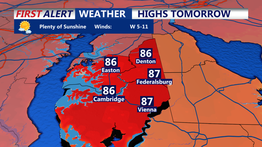


DELMARVA - On Tuesday, a building ridge will enhance subsidence, causing temperatures to rise into the mid to upper 90s with slightly higher dew points. This scenario increases the Heat Risk for the Delmarva Peninsula to moderate levels. The concern with the heat is significant, as temperatures will continue to build throughout the week. This early-season heat coincides with the end of the school year and a federal holiday, increasing the number of vulnerable communities and events. Several high-temperature records may be challenged or broken based on current forecast maximum temperatures. Consequently, a Heat Advisory has been issued for the region. Those sensitive to heat should take extra precautions during the day, as the potential for excessive heat will persist through the rest of the week.
Long Term (Wednesday Through Sunday):
Summary: Excessive heat is probable with little to no rain chances.
Guidance remains consistent, indicating an extended period of heat across the Delmarva Peninsula, with high temperatures reaching 94°F or higher. There has been almost no change in the forecast of an expansive and deep ridge centered over our region, with additional warming expected through Friday. The latest model run indicates a ridge higher than 600 dm centered over the region at 500 mb on Thursday. Coupled with well-above-normal temperatures at 925 mb and 850 mb, surface temperatures are expected to reach the upper 90s for most of the week. Heat advisories will likely extend beyond Tuesday, with the potential to be upgraded to Excessive Heat Warnings due to the unprecedented early-season heat impacts and duration over the region.
With warm air advection in place during the early part of the week and the strengthening of the 500 mb high towards the end of the week, the latter half is likely to be the hottest. The heat dome will maintain surface high pressure to our east, with surface flow more from the south. The southerly flow is expected to be fairly light, and moisture advection is minimal, so surface dew points should not be excessively high. Extended periods of hot temperatures tend to lower dew points during peak heating, which can be enhanced by dry or drying ground conditions. There will also be minimal relief at night, especially in urban areas, with lows only dropping into the 70s. The southerly flow should keep coastal areas noticeably cooler than inland areas, and a light flow, especially under the ridge, could allow sea breezes to extend further inland during the later afternoon hours. The ridge will feature plenty of dry air aloft, which limits cloud development and rain chances, particularly given the warm air aloft. Consequently, convective chances are minimal.