


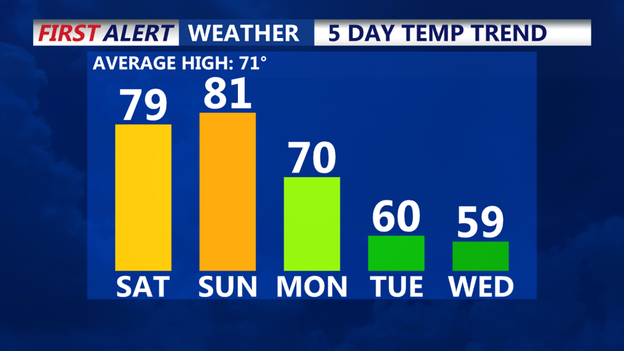


DELMARVA -- A weak cold front will pass through Delmarva on Saturday morning, but it won't significantly impact the temperatures. With mild conditions in place, high temperatures are expected to be a bit warmer than Friday, reaching the low to mid-70s across most of the area, with some spots climbing into the upper 70s. Winds will shift to the northwest, increasing to 10–15 mph by late morning, with gusts up to 20 mph. Skies will remain mostly sunny, making for a pleasant autumn day.

High pressure will start to move away from the region Saturday night, allowing a stalled frontal boundary to linger nearby. Although clouds will increase into early Sunday, no precipitation is expected. Overnight temperatures will be seasonable, dropping to the upper 40s to mid-50s.
Sunday, an area of low pressure will develop over the Midwest and track eastward, pushing the stalled boundary northward as a warm front. Delmarva will remain south of this boundary, allowing mostly sunny skies and warm temperatures to persist through the afternoon, with highs again reaching the 70s.
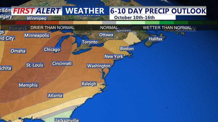
By Sunday night, the cold front associated with the low-pressure system will approach, bringing a slight chance of an isolated shower. However, the best chances for rain will remain to the north and west of Delmarva, so only a stray shower is possible overnight.
The cold front will cross Delmarva on Monday, bringing cooler, breezier conditions. Northwest winds may gust up to 30–35 mph as the cooler air filters in. High pressure will settle in behind the front, creating a dry, cool pattern through the middle of the week. Expect temperatures to average 5–10 degrees below normal, with potential for frost and even freeze warnings across parts of the region.
As high pressure strengthens over the Central and Eastern U.S., Delmarva will experience clear skies and crisp autumn temperatures through the middle of next week.
