


DELMARVA -- Another chilly night under the influence of strong high pressure centered to the north. Clear skies and calm winds will allow temperatures to plummet, with most areas dropping into the 30s tonight. Coastal locations will stay slightly warmer, hovering in the 40s, thanks to a light northeasterly breeze. Expect lows in the upper 30s inland and low 40s along the coast.
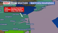
A Coastal Flood Watch remains in effect through Friday morning for Sussex and Kent Counties. Minor coastal flooding of 1 to 2 feet above ground level is possible during high tide cycles, driven by a combination of the full moon and persistent northeast winds. Residents in vulnerable coastal areas should take precautions and stay informed of local advisories.

Coastal Flood Watch Through Friday Morning
Tomorrow will begin with some sun, but cloud cover will gradually increase as a low-pressure system develops off the southeastern coast. High clouds will give way to thicker mid- and low-level clouds by the afternoon, especially across southern Delmarva. Despite the increasing clouds, the air remains dry, limiting rain chances during the day. High temperatures will remain below average, reaching the mid to upper 50s, with a light northeast to east wind.
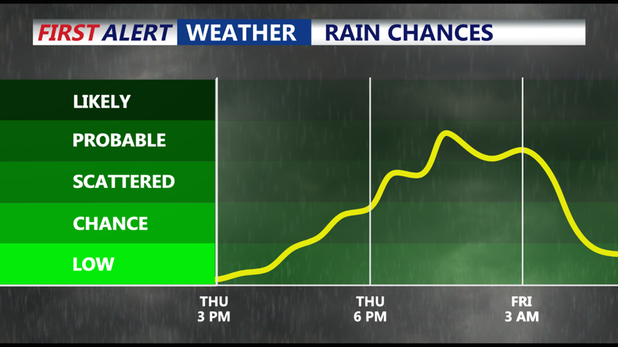
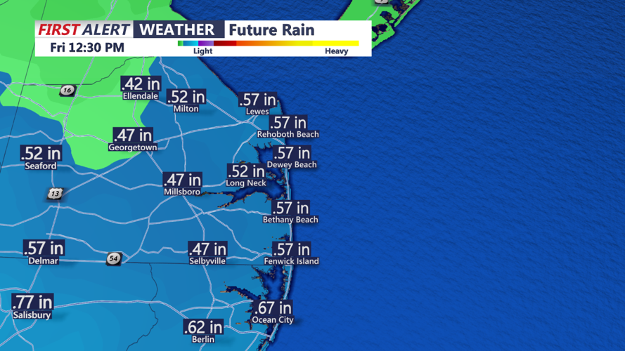
Rain chances increase Thursday evening into Friday morning as the low-pressure system offshore brings moisture into the region. The best chance for measurable rain will be across southern Delmarva, where a tenth to a quarter inch of rain is possible. Some areas may see up to a half an inch especially the further south you go. Overnight lows will stay above freezing in the 40s.

Rainfall totals Thursday Night-Friday Morning
By Friday, the low-pressure system departs, aside from a brief morning shower, drier air will move in and a gradual warming trend begins. Highs will climb into the upper 50s with clearing skies and a light northwest breeze.
Canadian high pressure takes control, bringing sunny and mild conditions to Delmarva. Saturday will feature highs in the lower 60s with a brisk northwest wind. Dew points will remain low, making for a crisp but pleasant fall day. Sunday looks equally mild, with highs again reaching the low 60s as the high slides off the Southeast coast.
A weak frontal system will approach late Sunday night into Monday morning, with a slight chance of isolated showers. While most guidance suggests minimal rainfall, a brief shower cannot be ruled out. Behind the front, high pressure will return, keeping conditions dry through midweek. Temperatures will remain unseasonably warm, with highs in the mid to upper 60s on Monday, cooling slightly into the low 60s by Tuesday and Wednesday.