


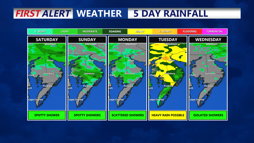


DELMARVA -- Will start the weekend with the possibility of fog across the region during the early morning hours. However, anticipated shower activity should help mix out the atmosphere, significantly limiting any dense fog development. The day will feature mostly cloudy skies, but there's a chance for a few peaks of sunshine in the afternoon. Highs are expected to reach the low to mid-80s, with inland areas possibly seeing temperatures climb into the mid-80s if enough sunshine breaks through. Beachgoers should be cautious, as a moderate risk of rip currents continues through the weekend. While a few isolated showers cannot be completely ruled out, the majority of the day will remain dry. Overnight, expect mild conditions with lows dipping into the low to mid-60s, and upper 50s in higher elevations.
Sunday will continue the trend of cloudy and unsettled weather as an upper-level low, currently positioned over the southern Ohio River Valley, begins to shift eastward. This will maintain mostly cloudy to overcast skies throughout the day with scattered showers possible across the region.
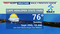
Please come out Sunday morning to Cape Henlopen State Park at 10AM for the Walk 4 Prostate Cancer. Chief Meteorologist Paul Williams will be the grand marshal, this a cause near and dear to his heart. Many other COAST TV News personalities will be in attendance. Hope to see you there!

The best chance for rain, about 25-35%, will be along and south of a stationary front that divides the Mid-Atlantic, Despite the dreary conditions, it won’t be a total washout, and some locations could remain dry. High temperatures will range from the mid to upper 70s. Overnight, expect lingering showers with lows ranging from the upper 50s to the low to mid-60s.
As we move into Monday, the upper-level low that has been affecting the region will begin to weaken and transform into an open trough, slowly progressing eastward. This transition will keep the weather unsettled, with periods of scattered showers expected throughout the day, though no significant rainfall is anticipated. The chance of precipitation is highest on Tuesday, with a 50-60% likelihood as a cold front approaches. By Wednesday, the front should clear the region, ushering in drier conditions and a return of sunshine to close out the workweek. Temperatures on Monday will be mild, similar to Sunday, with highs generally in the 70s.
As the cold front moves through by midweek, we can look forward to the return of high pressure, bringing drier and sunnier weather for the latter half of the week. Expect temperatures to remain seasonable with pleasant conditions as we head towards the weekend.