


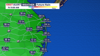


DELMARVA -- Tonight, low pressure offshore will bring light rain to portions of Delmarva, primarily the eastern shore of Maryland and southern Delaware. Rainfall amounts will be minimal, ranging from just a few hundredths of an inch to a tenth of an inch at most.

Rain tonight will be on the light side.
Many other areas may stay dry as the rain's northward progress halts overnight before sliding southward across the peninsula. Temperatures tonight will dip into the mid-40s across the region.
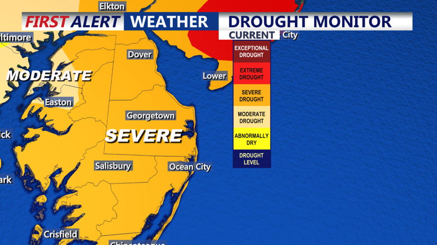
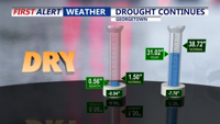
Despite showers, severe drought conditions persist on Delmarva as we continue to see rain deficit for the month and nearly an eight inch deficit for the year.

Rainfall deficit on Delmarva
By Friday, the coastal low will push farther offshore, allowing for gradual clearing throughout the day. Highs will climb into the mid-to-upper 50s under partly to mostly sunny skies as high pressure begins to build in. Friday night will see continued clearing and cooler conditions, with lows dropping into the mid-to-upper 30s.
As we head into the weekend, an upper-level ridge of high pressure will take over, bringing sunny and dry conditions to Delmarva on Saturday. However, it will be breezy, with winds gusting 20-30 mph, possibly up to 40 mph in higher elevations, as a modest pressure gradient develops between two offshore low-pressure systems. This, combined with dry air, could elevate fire weather concerns. Highs on Saturday will reach the low to mid-60s, marking the start of an above-normal temperature trend.

Weekend starts sunny with more clouds Sunday.
Winds will diminish Saturday night as high pressure settles closer to the region. With clear skies, most inland areas will experience radiational cooling, with lows dipping to around freezing. However, coastal zones and urban areas like the Philly metro may remain slightly milder, with lows in the upper 30s to low 40s.
Sunday will bring another sunny day with mild temperatures in the low to mid-60s. A weak frontal system is set to approach on Monday, but it appears to be moisture-starved and unlikely to produce meaningful rain. Ahead of the front, temperatures could reach the upper 60s on Monday, followed by slightly cooler but still mild conditions through midweek as high pressure returns.
Looking beyond midweek, there is some uncertainty, but medium-range guidance suggests a more active weather pattern could develop later in the week, potentially bringing unsettled conditions and some rain. Stay tuned for updates as the forecast evolves.