


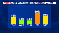

DELMARVA - A stalled front will keep Sussex County locked in a humid and unsettled weather pattern from Tuesday through Thursday morning, with repeated chances for thunderstorms and tropical rainfall.
Forecasters say the front, which moved through the region late Monday, is now expected to stall just south of the county before gradually lifting back north as a warm front by Thursday. This setup will allow waves of moisture to stream overhead, fueling scattered showers and thunderstorms each day.
On Tuesday, coverage of storms is expected to be somewhat limited compared to Monday’s widespread activity. Still, any storm that develops could produce torrential downpours capable of flash flooding, along with occasional lightning and isolated damaging wind gusts. Forecasters are watching for the possibility of low clouds and fog in the morning hours, especially where heavier rain fell overnight.
Wednesday brings continued uncertainty about where the stalled boundary will settle. If it remains to the south, storms may be more focused across southern Delaware and nearby coastal areas. However, the very humid air mass will persist across the entire region, and forecasters expect at least scattered showers and storms to develop by afternoon as temperatures rise.
By Thursday morning, the front is forecast to drift north, allowing southwesterly winds to draw in even warmer and more humid air. Temperatures could approach the low 90s, with heat index readings near or exceeding 100 degrees inland. This combination of high heat and lingering moisture may create hazardous conditions for those spending prolonged time outdoors.
Rainfall totals through Thursday morning could be locally significant, particularly if multiple rounds of storms repeatedly track over the same locations. Residents are urged to monitor the latest forecasts and be prepared for sudden changes in weather conditions, including the potential for flash flooding on roads and in low-lying areas.
Forecasters recommend using caution during any thunderstorms and never driving through floodwaters. Be sure to check for heat advisories if you plan to be outside later in the week.