


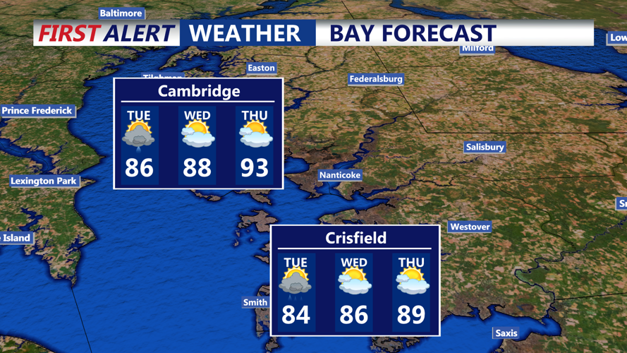


DELMARVA - A sweltering air mass will blanket the region through Wednesday, setting the stage for unsettled weather and periods of heavy rainfall.
A cold front is expected to push east through Sussex County Monday evening before stalling near or just south of the area. This front will remain in the vicinity into Wednesday, keeping the forecast unsettled. As it lingers, rounds of showers and thunderstorms are likely to redevelop each afternoon and evening.
Forecasters say the primary hazard will be localized flash flooding due to tropical downpours. Some storms could produce rain rates high enough to quickly overwhelm drainage systems, especially in low-lying or poor drainage areas. While severe storms are not widespread, forecasters caution there is a small chance—about 15 to 20 percent—that stronger cells could generate brief gusty winds known as wet downbursts.
The cold front’s exact position on Tuesday remains uncertain. If it stalls farther south, the most active storms could develop mainly over southern and eastern parts of the region. Even in that case, scattered thunderstorms and occasional heavy rain remain possible inland thanks to the lingering humidity and daytime heating.
By Wednesday, the front may start to drift northward as a warm front. With moisture still in place and little upper-level support to clear the air, another round of scattered storms could develop into the evening. Storm coverage is expected to be less widespread compared to Monday, but any storm that forms could produce locally heavy rain.
Residents are advised to remain alert for flash flood warnings and to avoid driving through flooded roadways. Forecasters also note that visibility could be reduced at times overnight if fog forms in areas where the heaviest rain falls.
Looking ahead, conditions may briefly dry out toward the end of the week before another cold front approaches Friday. Thursday could bring another surge of heat and humidity, with heat index values approaching 100 degrees in many inland locations.