


DELMARVA- A boundary dropping south through Delaware today could trigger a few showers through early afternoon. Winds shift to the north-northeast this afternoon under mostly cloudy skies, with temperatures remaining in the upper 60s and lower 70s.
For tonight, expect mainly cloudy skies with a chance of showers late tonight into Saturday morning. Lows in the 50s.

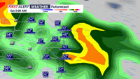
The weekend could begin with a few showers and thunderstorms Saturday morning, otherwise more clouds than sun and temperatures in the 50s much of the day, then 60s and 70s later in the day.
Saturday night will be dry and mild with lows in the 60s.

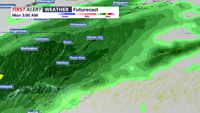
Another surge of warmth is expected Sunday with lots of clouds, temperatures will warm into the 70s. A strong cold front will trigger showers and possible thunderstorms Sunday night into Monday morning. Some of the rain could be heavy at times.
Much colder air follows the front with high temperatures in the low to mid 50s Monday through Wednesday. Lows dip into the 30s beginning Tuesday morning, with a frost and hard freeze possible Wednesday morning.