


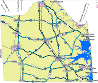


SUSSEX COUNTY, Del. - As Sussex County braces for a snowstorm, officials are asking locals to familiarize themselves with designated evacuation routes to ensure safety during severe weather events.
The Sussex County Emergency Operations Center emphasizes the importance of preparedness, by knowing your snow evacuation routes.
U.S. Route 113 Northbound: Extends from the Maryland state line through Sussex County to the Kent County line.
U.S. Route 13 Northbound: Runs from the Maryland state line up to the Kent County line.
Delaware Route 1 Northbound: Stretches from the Maryland state line, passing through coastal areas, to the Kent County line.
Delaware Route 54 Westbound: Connects from Delaware Route 1 to U.S. Route 13.
Delaware Route 26 Westbound: Links Delaware Route 1 to U.S. Route 113.
Delaware Route 24 Westbound: Extends from Delaware Route 1 to U.S. Route 113.
Below are the specific snow evacuation routes for towns and cities within their respective limits. If your town or city is not listed, this article will continue to be updated as new information becomes available.
The following streets are hereby designated as snow emergency routes:
- Main Street (Northbound): From Route 113 to Route 24 bridge, both sides
- Washington Street (Southbound): From Route 24 bridge to Route 113, both sides
- Dewey Avenue: From Kings Highway to Savannah Road
- Kings Highway: From the city limits to Savannah Road
- W. Fourth Street: From New Road to Savannah Road
- Savannah Road: From the city limits to Bayview Avenue
- Bayard Avenue: Both sides, entire length
- Rehoboth Avenue: Both sides, entire length
- State Road: Both sides, entire length
The snow emergency routes consist of the following streets:
- East Market Street
- West Market Street
- North Bedford Street
- South Bedford Street
- Bridgeville Road
- East Pine Street
- West Pine Street
- North Race Street
- South Race Street
- North Front Street
- South Front Street
- East Laurel Street (North Bedford Street to North Race Street)
- West Laurel Street (North Bedford Street to North Front Street)
- Edward Street (North Bedford Street to North Front Street)
- West North Street (North Bedford Street to DuPont Highway, Route 113)
- Albury Avenue (East Market Street to Cedar Street)
- North: Route 1
- West: Route 26
- Start at State Route 1 and Evergreen Road (McDonald's)
- Drive northbound on Route 1 to Garfield Parkway (Del. Route 26)
- Turn left onto Garfield Parkway (Del. Route 26)
- Continue on Vines Creek Road (Del. Route 26) to Dagsboro
- Turn right on Main Street
- Turn left on Clayton Street to Route 113 or proceed north on Dagsboro Road to Route 113
- Proceed on Route 113 to points north
DelDOT's interactive map provides real-time updates on state road conditions, which can be accessed through their website.