


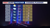
For the rest of Saturday afternoon and evening skies remain mostly cloudy skies with diminishing winds and temperatures in the 50s.
From
To

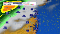
Low pressure slides to our south later today into early Monday morning bringing a soaking rain.

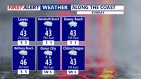
A chilly start to our Saturday with highs in the 40s with less wind. A bit milder for Sunday.

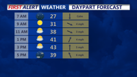
Drying out this afternoon and turning colder with temperatures falling from the 50s into the 40s.

A breezy and mild morning, then windy and turning colder this afternoon into early next week.


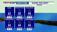
High pressure continues to move offshore this evening, as southerly winds pull in warmer air, allowing afternoon highs to reach the mid to upper 60s this weekend. We'll see a better chance of showers Sunday. Then a taste of winter early next week.

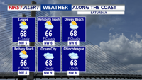
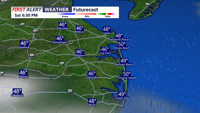
High pressure slides to the east on Saturday, allowing for warmer conditions with increasing clouds. Even warmer on Sunday with more clouds and breezy conditions.

Unsettled weather for the rest of the weekend with more clouds than sun and frequent showers.

High pressure has moved east of Delmarva, allowing warm and more humid air to move into the region. Summer temperatures will stick around into a part of the weekend with a few showers and storms possible.

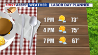
Labor Day will be a bit cooler for Delmarva, along with breezy conditions. Expect mostly sunny skies and afternoon highs in the mid 70s, with low 70s at the beaches.