


Sussex County faces light snowfall Tuesday night followed by a bitter arctic cold front this weekend, bringing subzero wind chills and potential snow squalls.
From
To


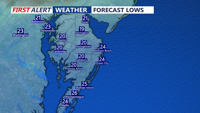
A brief brush with winter weather starting this afternoon as a low-pressure system tracks northward. Rain will transition to sleet and snow by evening, though accumulation will remain light across most of the region. Following the system’s passage, an arctic cold front will plunge temperatures into the single digits by Monday night, bringing dangerously cold wind chills and potential hazards for residents and infrastructure.

Delmarva will experience a strong cold front tonight, leading to rain and potential snow Sunday before an arctic air mass settles in, bringing dangerously cold temperatures into the early week.

A warm front will bring milder conditions and light rain to Delmarva on Saturday before a strong arctic cold front ushers in frigid temperatures and a chance for snow Sunday night.

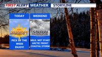
A pleasant Friday and mild damp start to the weekend for Delmarva before another round of wintry weather arrives and an arctic blast early next week, bringing accumulating snow Sunday evening and dangerously cold temperatures into midweek

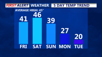
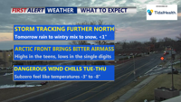
Snow showers this evening as a weak low-pressure system passes through. Friday promises sunshine and mild temperatures near 40 degrees, the most pleasant day in the forecast. However, a strong arctic cold front on Sunday could bring light snow and usher in some of the coldest air of the season next week, with subzero wind chills and potential impacts on people, animals, and infrastructure.

Sussex County will experience light snow Thursday evening, with milder temperatures and rain on Saturday before an arctic cold front brings frigid conditions next week.