


Snow continues this morning with slippery travel before ending early this afternoon, followed by increasing winds and dangerously cold wind chills tonight into Monday.


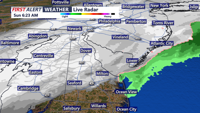
Snow is expected to develop early Sunday morning and continue through late Sunday morning. Accumulations are expected to be in the 1-3" range, with slick roads Sunday morning.


Snow is expected to develop early Sunday morning and continue through late Sunday morning. Accumulations are expected to be in the 1-3" range, with slick roads Sunday morning.

Another round of accumulating snow is expected early Sunday, then a blast of bitter cold weather into early next week.

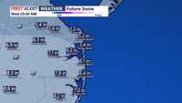
A winter storm will bring heavy snow, strong winds, and hazardous travel conditions to Sussex County and Ocean City from Tuesday afternoon through early Wednesday, followed by a wintry mix before tapering off late Wednesday night.


A winter storm will bring heavy snow, strong winds, and hazardous travel conditions to Sussex County and Ocean City from Tuesday afternoon through early Wednesday, with accumulations of 5-7 inches and locally higher amounts possible.


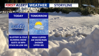
A brief brush with winter weather starting this afternoon as a low-pressure system tracks northward. Rain will transition to sleet and snow by evening, though accumulation will remain light across most of the region. Following the system’s passage, an arctic cold front will plunge temperatures into the single digits by Monday night, bringing dangerously cold wind chills and potential hazards for residents and infrastructure.

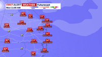
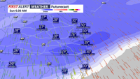
Delmarva is currently experiencing heavy snowfall, with rates of 1 to 2 inches per hour. The snow will continue through the morning, before a brief lull this afternoon, followed by another round of snow this evening. Early snowfall reports show 3-6 inches already on the ground in many areas. Travel today is not recommended as roads are covered in snow, and conditions will continue to worsen.

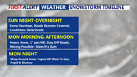
Sunny skies this morning, but frigid wind chills and gusty winds will make it feel like the teens. Clouds will increase late Sunday ahead of an overnight snowstorm that could bring 4 to 10 inches of snow to the region. Snow may mix with sleet or freezing rain along the southern coast, with blowing and drifting snow expected Monday night into Tuesday as winds intensify.