


DELMARVA - As of Monday evening, high pressure is in control over the region, bringing clear and dry conditions to Sussex County and the Ocean City area. However, the quiet weather will be short-lived as a winter storm is set to arrive Tuesday afternoon, bringing accumulating snowfall, strong winds, and hazardous travel conditions.
A developing low-pressure system over the Gulf Coast will strengthen as it moves northeast, with a secondary low forming off the Mid-Atlantic coast Tuesday night. This setup will result in widespread snowfall across coastal Delaware and eastern Maryland, with the heaviest snowfall occurring Tuesday evening into early Wednesday morning. A second system will bring a wintry mix on Wednesday, further complicating travel.
Detailed Forecast
Monday Night:
High pressure keeps the region dry with mostly clear skies through the evening. Clouds will increase after midnight as the storm system approaches. Temperatures will drop into the teens and 20s, with calm winds limiting significant wind chill effects.Tuesday Morning:
Dry conditions continue through the morning, but cloud cover thickens. Temperatures will gradually rise into the upper 20s to low 30s.Tuesday Afternoon:
Snow is expected to develop around midday and spread across the region, intensifying through the late afternoon. Accumulations will begin immediately, especially on untreated roads. Temperatures will remain near freezing, allowing snow to stick efficiently.Tuesday Evening:
Heavy snowfall will peak during the evening hours, with rates approaching 1 inch per hour at times. Strong northeast winds of 20-30 mph, with gusts up to 40 mph, may cause blowing and drifting snow, reducing visibility to near zero in spots. Travel will become hazardous or impossible.Overnight into Wednesday Morning:
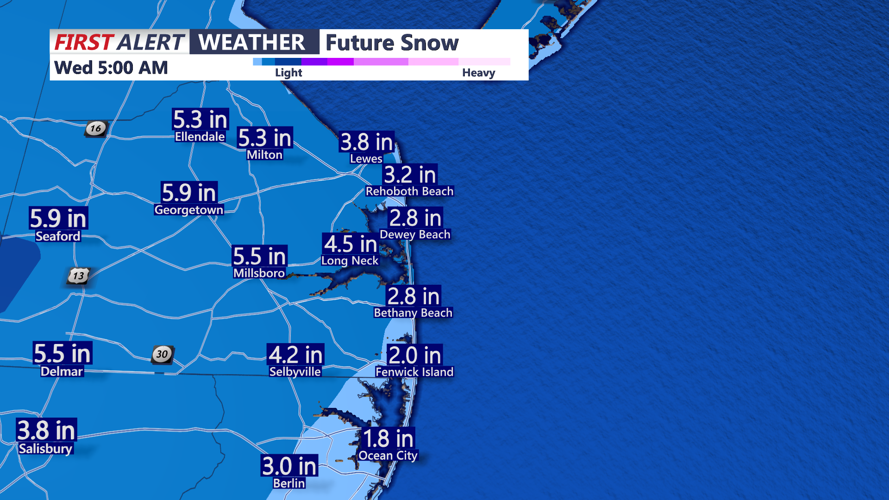
Snow will continue into early Wednesday morning, tapering off before sunrise. Storm total accumulations are expected to range between 5-7 inches across most of Sussex County and Ocean City, with locally higher amounts up to 9 inches possible in isolated areas.Wednesday Afternoon and Evening:
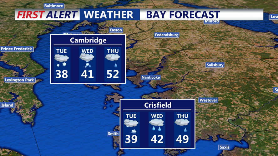
A brief lull in precipitation is expected, but another low-pressure system will arrive from the west. This second system will bring a mix of snow, sleet, and rain. Wintry precipitation is likely in the afternoon, changing to rain overnight as temperatures rise.
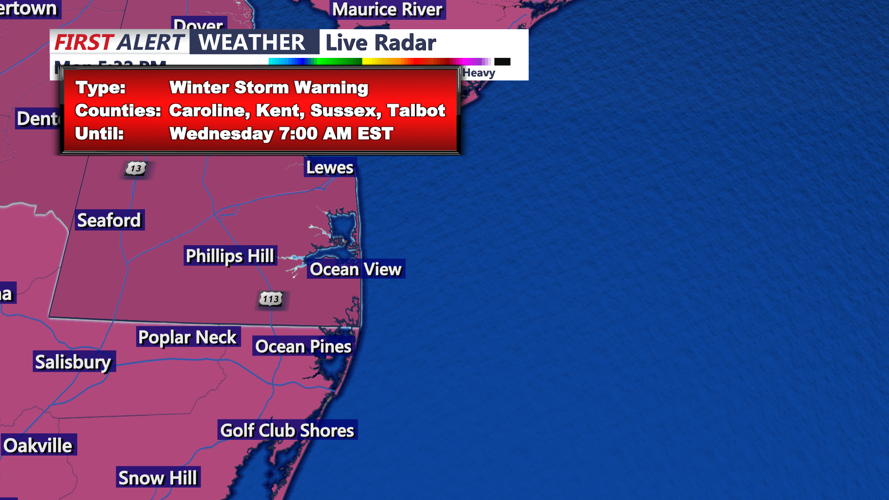
Winter Storm Warning Details
The National Weather Service has issued a Winter Storm Warning for Sussex County, coastal Sussex County, and Ocean City from 1:00 PM Tuesday to 7:00 AM Wednesday.
- Expected snowfall: 5-7 inches, with locally higher amounts possible.
- Winds: Northeast 20-30 mph, gusts up to 40 mph.
- Impacts: Roads will become snow-covered and hazardous. Blowing snow may reduce visibility to near zero. Power outages are possible due to heavy, wet snow and strong winds.
How to Prepare
- Travel: If you must travel, keep an emergency kit in your car, including blankets, food, water, and a flashlight. Consider delaying non-essential trips until conditions improve.
- Power outages: Charge electronic devices and prepare for potential outages. Have extra batteries, candles, and a backup heat source if needed.
- Home preparation: Keep extra food and supplies on hand. Avoid using generators indoors to prevent carbon monoxide poisoning.
- Stay informed: Follow local weather alerts and road condition updates.
Looking Ahead
By Wednesday night, the second system will bring a mix of wintry precipitation before transitioning to rain. The storm will move offshore by Thursday morning, with dry conditions returning. Another storm system is possible over the weekend, which could bring additional precipitation.
Residents in Sussex County and Ocean City should prepare for hazardous winter conditions Tuesday into Wednesday and stay updated on the latest forecasts as the storm approaches.