


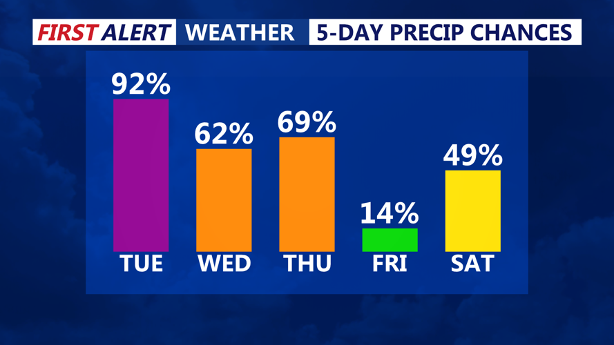


A developing storm system will move through the Mid-Atlantic on Tuesday, bringing significant snowfall to Sussex County and Ocean City. Another system will follow on Wednesday, delivering a mix of wintry precipitation before moving offshore by Thursday morning.
Storm Overview
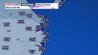
A powerful winter storm is set to impact Sussex County and the Ocean City area beginning midday Tuesday, with widespread snow and strong winds leading to dangerous travel conditions. A second low-pressure system will develop by Wednesday, bringing a transition from snow to a wintry mix before tapering off late Wednesday night.
Snowfall accumulations are expected to reach 5-7 inches, with isolated areas possibly seeing totals up to 9 inches. Winds will increase to 20-30 mph, with gusts up to 40 mph, creating areas of blowing snow and reduced visibility.
Detailed Forecast
Tuesday Morning:
Conditions will remain dry but cloudy as the storm system approaches from the southwest. Temperatures will start in the upper 20s to low 30s.Tuesday Afternoon:
Snow will begin around midday, quickly increasing in intensity. The heaviest snow is expected between the late afternoon and evening, leading to rapid accumulations.Tuesday Evening and Overnight:
Snowfall rates of up to 1 inch per hour are likely during peak intensity. Roads will become hazardous, and visibility may drop significantly due to gusty northeast winds. Snow will taper off before sunrise on Wednesday.Wednesday Morning and Afternoon:
A brief lull is expected in the morning before a second system arrives. This system will bring another round of precipitation, starting as snow but transitioning to a mix of sleet and rain as temperatures rise.Wednesday Night:
Precipitation will gradually shift to rain before ending late in the night.
Winter Storm Warning Details
A Winter Storm Warning is in effect for Sussex County and Ocean City from 1 p.m. Tuesday to 7 a.m. Wednesday.
- Snowfall totals: 5-7 inches, locally higher amounts possible.
- Winds: Northeast 20-30 mph, gusts up to 40 mph.
- Impacts: Snow-covered roads, dangerous travel, potential power outages due to wet snow and strong winds.
Preparation Tips
- Travel: Avoid unnecessary travel during the storm. If travel is necessary, carry an emergency kit with blankets, food, water, and a flashlight.
- Power outages: Charge devices in advance, and have flashlights, extra batteries, and alternative heat sources ready.
- Home readiness: Stock up on essentials and check heating systems. Keep a shovel and salt on hand for clearing snow.
- Stay updated: Follow weather alerts and local road conditions for the latest updates.
What’s Next?
By Thursday morning, the storm will move offshore, allowing drier conditions to return. However, another system could bring additional precipitation later in the week. Residents should stay alert for forecast updates as conditions develop.
