


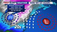
Colder-than-normal temperatures have settled across Delmarva, with highs ranging from the mid-30s to low 40s. The chill deepens by Thursday and into the weekend, as an arctic cold front approaches. While light snow is possible Friday, more impactful snow squalls and dangerously cold wind chills are expected Friday night into Saturday. Gusty winds behind the front may reach 50 mph, especially near the coast.

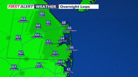
Overnight lows dip into the 40s as high pressure keeps skies clear and winds calm.

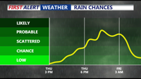
High pressure dominates Delmarva tonight, bringing calm winds, clear skies, and sub-freezing overnight temperatures inland. Rain chances increase late Thursday into Friday as a low-pressure system develops nearby, but precipitation amounts are expected to be light. The weekend promises drier and milder conditions as Canadian high pressure builds into the region, with temperatures climbing into the 60s by Saturday. A weak frontal system may bring isolated showers late Sunday into early Monday, but dry weather returns midweek with above-normal temperatures.

High pressure remains over the Delmarva region, bringing clear skies and mild conditions through Monday, with a chance for patchy fog overnight.

High pressure will maintain dry and cool conditions across the Delmarva Peninsula through Tuesday, with clear skies and a persistent northerly breeze.

Tonight, Delmarva will experience clear skies and calm conditions, with temperatures dropping into the mid to upper 50s. Saturday will bring slightly warmer weather with highs reaching the mid-80s as high pressure shifts offshore, leading to a light southwesterly breeze.

High pressure will bring calm and sunny conditions to Delmarva this weekend, with temperatures gradually returning to seasonal norms. By early next week, there is a chance of showers and thunderstorms as a new system approaches the region.

Delmarva will experience mostly calm and dry weather through midweek as weak high pressure maintains its influence. A few passing troughs may bring increased cloudiness and an isolated shower, but the region will remain largely dry. Temperatures will be seasonable, with cooler conditions expected by Tuesday. Looking ahead, a shift in weather patterns is expected over the weekend as a low-pressure system approaches, bringing the potential for more significant weather changes.