


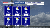
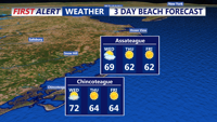
Dry and mostly calm conditions are forecast from early Friday morning into early Saturday, with chilly temperatures and partly cloudy skies prevailing across Sussex County.
From
To

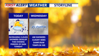
After a cold start this morning, Delmarva will see increasing clouds today, chilly rain late tonight into Wednesday morning, and mostly cloudy conditions through the end of the week as multiple weak systems move through the region.

A cold front moves across Delmarva tonight, bringing light showers before cooler, breezier weather settles in midweek. Temperatures dip below seasonal averages Wednesday and Thursday, with potential frost in some inland areas by Thursday night. High pressure returns to close out the week with cool but mostly dry conditions heading into the weekend.

Sunshine returns to Sussex County Wednesday, but brisk northwest winds and chilly overnight lows will follow into early Thursday.

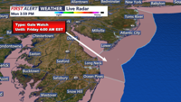
A coastal low-pressure system will keep beach communities in Sussex County, Delaware, under clouds, rain, and gusty winds from early Friday through late Saturday

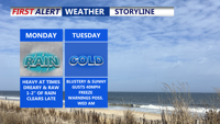
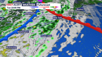
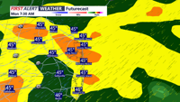
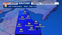
Delmarva can expect a soaking start to the week, as widespread rainfall impacts the region Monday due to a stalled front and weak low-pressure system. Rainfall totals between 1 and 1.5 inches, with isolated areas receiving up to 2 inches, will be followed by a sharp cold front overnight into Tuesday. Behind it, colder and drier air arrives, bringing gusty winds, temperatures struggling to reach 50 degrees, and the first widespread freeze of the season by Tuesday night. Conditions briefly improve midweek before another storm system approaches late Thursday into the weekend.

A stalled front and incoming low pressure will bring widespread rain to Delmarva Sunday night into Monday. Expect up to 1.5 inches of rainfall, a sharp temperature drop, and gusty winds by midweek. After a brief dry spell, unsettled weather returns late Thursday into the weekend, with a chance of a nor’easter developing by Saturday.

A weak cold front moving through the region will bring frigid overnight temperatures and mostly clear skies Friday evening, followed by a brisk and sunny Saturday.

Delmarva will see increasing clouds Monday evening as a weak low-pressure system brings light snow showers late Monday night into early Tuesday. High pressure returns by Tuesday evening, ensuring dry but chilly weather midweek.

Delmarva faces cold, dry weather Monday evening through Tuesday evening as high pressure dominates, with temperatures dipping into the teens overnight and remaining chilly throughout the day.