


DELMARVA - Friday begins on a soggy and gray note for Rehoboth Beach, Bethany Beach, Lewes and surrounding areas. A developing coastal low will move northward off the Mid-Atlantic coast, delivering intermittent rain showers through the morning and early afternoon. While rainfall will be light and scattered early, it will become more widespread and heavier by late afternoon and evening.
Winds will increase steadily through the day, with northeast gusts up to 30–35 mph along the shoreline
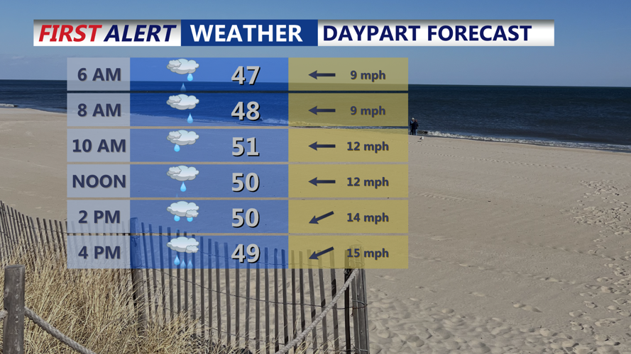
Temperatures will struggle to climb, with highs only reaching the upper 40s to low 50s°F
Expect a chilly, damp day—unseasonable for mid-April
Friday Night – Storm Peaks
The peak impact from the coastal system will occur Friday night. Rain may fall heavily at times, and there's even a small chance of a rumble of thunder across far southern Delmarva. Winds from the northeast will remain strong, gusting to 35 mph or higher along the coast.
Rainfall totals could reach 0.5 to 1 inch overnight
Minor flooding in urban and poorly drained areas is possible, but widespread flooding is not expected
Temperatures will dip into the low to mid 40s°F overnight
Saturday, April 12 – Rain Lingers, Wind Continues
While the low-pressure system will slowly move farther offshore, its broad circulation and upper-level support will keep clouds and scattered rain showers over the beach communities well into Saturday.
Light to moderate showers are possible throughout the day, especially in the morning and early afternoon
Winds remain breezy from the northeast, gusting 20–30 mph.
High temperatures stay well below normal, barely reaching the low 50s°F
Rain should begin to taper off by late Saturday night, but skies will remain mostly cloudy
Impacts and Preparedness
Beach erosion and minor coastal flooding could occur, particularly during high tide cycles Friday night and Saturday morning
Outdoor events and travel may be disrupted by wet roads and strong winds
Layered, waterproof clothing is recommended for anyone venturing outside
Rainfall Totals and Outlook
Storm total rainfall from Thursday night through Saturday night is expected to be 1 to 1.5 inches, with isolated spots receiving closer to 2 inches
Rivers and streams may rise, but no significant flooding is forecast at this time
The system exits late Saturday, with drier and brighter weather returning by Sunday