


Light snow is expected to arrive late Friday in Sussex County, with minor accumulation possible before tapering to scattered snow showers or a brief squall early Saturday as colder air moves in.


Sussex County is expected to stay mostly calm through Friday evening, with light snow developing late and a much more dangerous wind-and-cold outbreak slated for the weekend.

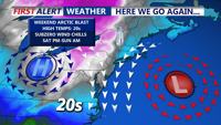
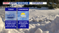
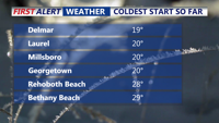
Colder-than-normal temperatures have settled across Delmarva, with highs ranging from the mid-30s to low 40s. The chill deepens by Thursday and into the weekend, as an arctic cold front approaches. While light snow is possible Friday, more impactful snow squalls and dangerously cold wind chills are expected Friday night into Saturday. Gusty winds behind the front may reach 50 mph, especially near the coast.

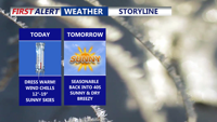
It’s Groundhog Day, and Punxsutawney Phil is calling for six more weeks of winter—but the COASTTV First Alert Weather team is already ahead of him, tracking more arctic air for Delmarva even after a short-lived warm-up. We’ll squeeze out some milder temperatures Tuesday, but a pair of clipper systems could bring light snow chances midweek and again Friday night, followed by another blast of bitter cold this weekend.

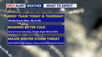
Delmarva gets a brief break with sun and milder temperatures through Thursday, but an arctic blast late Friday and a potential Saturday night-to-Monday storm could bring dangerous wind chills and significant snow.

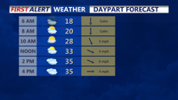
Wind chills in the teens will linger across Delmarva today before a short-lived warmup Thursday, we are watching a potentially impactful winter storm late Saturday through Sunday.

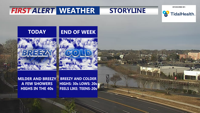
A bit warmer and breezy for the rest of Wednesday, then colder again to end the week. Some snow possible on Sunday.

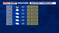
A midweek storm brings morning rain Wednesday before colder, gusty conditions return overnight.

A brief round of midweek rain follows a frigid Tuesday night as a fast-moving system sweeps through the region.