


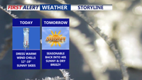


DELMARVA -- Today is shaping up as the coldest day of the week across the Delmarva Peninsula, with afternoon highs expected to top out in the mid- to upper 20s north to the low 30s farther south. West-northwest wind gusts up to about 25 mph will make it feel more like the teens for much of the day.

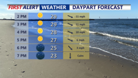
Mostly sunny skies, highs 25 to 32, wind chills in the teens for most of the day.
Winds are expected to ease tonight under mainly clear skies, allowing temperatures to drop quickly. Overnight lows are forecast to range from about 12 to 20 degrees across the peninsula.
Sunshine continues Wednesday, with seasonable highs in the low to mid 40s. A weak “clipper” system could pass late Wednesday night, bringing a brief sprinkle, though most spots stay dry.
Thursday, looks like the pick of the week, with partly cloudy skies and milder highs in the low to mid 50s. Another arctic front is expected to arrive Friday night, setting up a prolonged stretch of below-normal temperatures into the weekend.

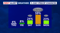
Tracking the possibility of significant snow over the weekend.
The COASTTV First Alert Weather team is also increasingly watching the potential for an impactful winter storm late Saturday-Monday, though confidence in exact track and snowfall amounts remains low.

Growing concern of a high impact winter storm late Saturday night-Monday on Delmarva. Lots of uncertainty with the overall track.
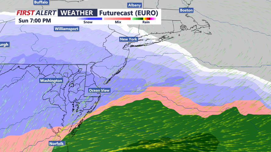
Current guidance broadly suggests a low-pressure system may develop near Texas on Friday and move along the Gulf Coast into Saturday before tracking toward the North Carolina coast and then offshore by Sunday into Monday. A recent trend has nudged the projected precipitation shield farther north, increasing the odds that the peninsula sees potentially significant winter weather, but small shifts in the storm track could mean big differences in who gets the heaviest snow. Stay with the First Alert Weather team through the week.
