


The low clouds and fog have burned off for inland areas with temperatures in the 60s this afternoon, but only 40s at the coast.
From
To

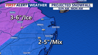
A Winter Storm Warning continues for the entire region beginning 7 pm Saturday and continues until 7 am Monday.

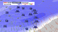
A dry and milder start to the weekend, then morning snow on Sunday, followed by the coldest airmass of the season so far.

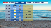
More clouds than sun this weekend and chilly. Then much colder early next week.

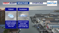
From early Thursday through early Friday, Sussex County’s beach communities will see persistent cloud cover, seasonable temperatures, and a low chance of spotty sprinkles before milder, wetter weather approaches overnight.

Sussex County’s beach communities can expect mostly cloudy, cool conditions from late Wednesday through late Thursday, with spotty drizzle possible but largely dry weather overall.

High pressure brings mainly dry but stubborn cloud cover through Thursday, with a weak front moving in Friday and low pressure tracking near the region Friday night into Saturday. Sunshine returns Sunday before another cold front crosses Monday.

High pressure continues to slide off the coast overnight into Sunday, ushering in warmer air and breezy conditions. A Yellow Alert is in effect for Monday morning for strong winds and heavy rain.

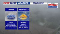
A cold front will slide southeast through the region this evening, but it’s expected to pass without rain and with little added cloud cover. The main change will be a noticeable uptick in winds and a refreshing push of cooler air.

A departing coastal low keeps skies cloudy and winds gusty across Delmarva today, but drier, cooler air arrives midweek as a cold front sweeps through. Temperatures will dip into the 30s and 40s by midweek nights, with high pressure bringing sunshine and calmer weather by Friday. Another warm-up and a chance of showers are expected by the weekend.