A sharp shot of arctic air will keep Sussex County cold and windy from early Tuesday through early Wednesday, with harsh wind chills in the teens and 20s and only modest improvement by Tuesday night.
A sharp shot of arctic air will keep Sussex County cold and windy from early Tuesday through early Wednesday, with harsh wind chills in the teens and 20s and only modest improvement by Tuesday night.
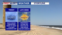
High pressure moving in from the north will push Hurricane Humberto and Imelda out to sea, bringing sunny skies and seasonable temperatures to Delmarva. Coastal winds and dangerous rip currents, however, remain a concern through the week.
A stretch of fair, cooler-than-average weather is expected in Sussex County from late Monday through late Wednesday, ahead of heat and humidity returning later this week.
Saturday afternoon will kick off a stretch of warm and muggy weather across Delmarva, with partly sunny skies and highs in the 80s. While most of the region should stay dry this weekend, low clouds and patchy fog will return overnight, and a few isolated thunderstorms are possible Sunday over the Eastern Shore. By Monday, an approaching cold front will bring more widespread showers and storms. Temperatures will remain above normal into late next week, with heat indices potentially nearing 100 degrees.
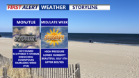
A stalled front lifting north will trigger rounds of thunderstorms across Delmarva starting Monday and lasting into Tuesday night. With temperatures climbing into the upper 80s to low 90s and abundant moisture, the atmosphere will become increasingly unstable. Forecast models point to a heightened risk of damaging wind gusts and localized flash flooding, especially Tuesday, when a Slight Risk for severe weather has been issued. Quieter and more pleasant weather is expected to settle in by midweek and continue through the Fourth of July holiday weekend.
Sunday brought oppressive heat and humidity fueled strong thunderstorms across Sussex County. Flash flooding quickly inundated coastal communities, while a microburst near Laurel generated wind gusts nearing 60 mph. Additional rounds of storms are expected Monday and Tuesday, with a heightened risk of damaging winds and flooding.
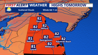
High pressure offshore will bring dry, hazy, and seasonably warm conditions to Delaware’s beach towns through late Wednesday before unsettled weather approaches later in the week.
"Delmarva will enjoy unseasonably warm and sunny weather on Wednesday, with highs near 80 degrees and gusty southwest winds, before a cold front brings a slight chance of showers and cooler temperatures by evening."