


DELMARVA -- A fall-like airmass has finally arrived. A stretch of clear and seasonable weather beginning today as Canadian high pressure builds in from the north, shunting Hurricane Humberto and Imelda out to sea.

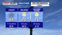
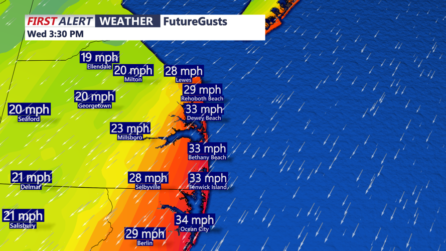
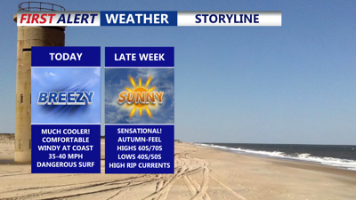
Mostly sunny skies, much cooler and comfortable, breezy conditions especially at the beaches gusts 35 MPH.
As the tropical systems drift eastward, skies will clear with sunshine spreading across the region. Highs will reach the upper 60s to low 70s, which is typical for early October. Winds remain a factor, however, with gusts of 25 to 35 mph along the coast and 15 to 25 mph inland. Beach communities will gusts up to 40 mph. Dangerous swells and rip currents will persist, with waves building between six and 11 feet. The high rip current risk is expected to last through the end of the week. Coastal Flood Advisories are up until 8PM for the DE coast, could see up to a foot of inundation during the high tide cycle through this evening.

Breezy afternoon especially at the beaches, gusts out of the northeast 35 MPH. Dangerous risk of rip currents and high surf.
Winds will ease tonight as the high moves closer, though a crisp chill remains in the air. Overnight lows will dip into the upper 40s away from the coast and settle in the low to mid-50s along the shoreline.

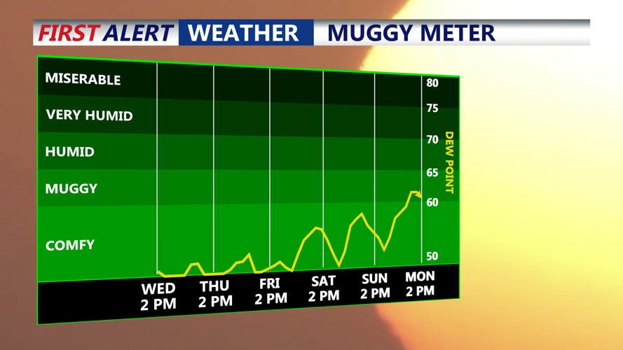
Fall airmass has moved into Delmarva, expect dry conditions and low humidity into the weekend.
On Thursday, the center of high pressure will be positioned over New England, extending south into the Mid-Atlantic. Both Humberto and Imelda will be well east of the coast by then, leaving Delmarva with another cool and dry day. Highs will top out in the mid to upper 60s with patchy high clouds limiting radiational cooling Thursday night. Temperatures will settle into the low to mid-50s.
By Friday, the high will shift closer to Long Island, ushering in slightly warmer air. Highs will reach the low 70s Friday afternoon before slipping into the upper 40s and low 50s overnight.
Looking absolutely perfect for Country Calling in Ocean City, kicking off Friday through the weekend. Certainly much better than last weekend.
The weekend will bring a milder trend as the high sets up just off the Mid-Atlantic coast. Highs on Saturday are expected in the mid to upper 70s. From Sunday through Tuesday, temperatures will climb further, reaching the upper 70s to low 80s. Nighttime lows will range from the low 50s over the weekend to the upper 50s and low 60s early next week.
Most of the period will be dry, with sunshine dominating through Monday. By Tuesday afternoon, a cold front approaching from the west could bring a few showers and thunderstorms to the region.