


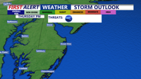
Thunderstorms and heavy rain Thursday will clear out by early Saturday, bringing drier, seasonable weather to Sussex County and the Atlantic coast of the Delmarva Peninsula.
From
To

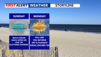
Clouds and scattered showers linger across Delmarva Sunday as a nearly stationary front and weak low pressure system pass through the region. Highs will remain cool, in the low 70s, before conditions clear late in the day. Dry weather and seasonable temperatures return Sunday night into Monday, with partly sunny skies and highs in the mid-70s. A weak coastal low could increase cloud cover Tuesday into Wednesday, followed by a stretch of dry, pleasant weather for the latter half of the week.

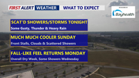
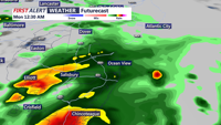
Scattered showers and thunderstorms will move across Delmarva Saturday evening, with the severe threat ending after 9 p.m. Some storms could still bring gusty winds, heavy rainfall, and localized flash flooding before overnight lows dip into the low to mid-60s. Much cooler air arrives Sunday as highs hold in the 60s, with a stalled front keeping scattered showers in the forecast. Skies will clear Sunday night, with lows in the mid-50s. Sunshine returns Monday with pleasant highs in the low to mid-70s, though clouds will increase Monday night as a weak coastal low approaches.

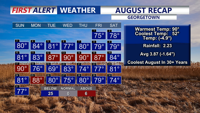
August closed out as the coolest in more than 30 years for Georgetown, with 25 days of below-average temperatures and limited rainfall leaving parts of Delmarva abnormally dry. Tonight brings clear skies with lows in the 50s and 60s. Labor Day will be sunny and mild in the upper 70s, followed by a stretch of dry weather before rain chances return late Thursday into Friday.

A cold front will usher in cooler-than-normal weather for inland and coastal Sussex County late this week and into the holiday weekend.

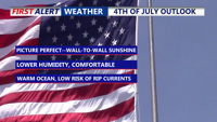
A reinforcing cold front will bring clear, comfortable conditions to Delmarva tonight, setting the stage for a sunny and pleasant Independence Day. High pressure will keep the region tranquil through the weekend, with temperatures in the 80s and low humidity. Warmer, more humid, and unsettled weather is expected to return early next week, with chances for showers and thunderstorms by Tuesday and Wednesday.

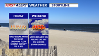
Delmarva’s weather pattern through the weekend and into next week will be dominated by a series of frontal boundaries bringing waves of warmth, humidity, and scattered thunderstorm chances. Friday begins cooler with cloud cover and a few showers, but a shift to a more southerly flow will increase temperatures through the weekend. The region could see highs in the 90s by early next week before another cold front arrives with a possible round of thunderstorms. Despite the unsettled pattern, extreme heat and widespread severe weather are not expected.

Showers and thunderstorms begin early Tuesday in Sussex County, with improving conditions by Tuesday night and clear, warm weather expected into Thursday morning.


Delmarva starts the week with marine clouds and patchy fog as an onshore flow keeps skies gray and temperatures mild. A cold front will bring showers and a low-end severe threat Tuesday before high pressure brings sunshine and near 90-degree warmth by midweek. Rain chances return by the weekend as another front approaches.

While severe storms remain west and south of the region, Delmarva starts the week under persistent cloud cover, patchy fog, and a low-end risk of isolated storms as a cold front approaches. Warmer, sunnier days are on the horizon by midweek.