


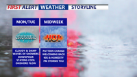
Delmarva begins the week with damp, gray skies and cooler temperatures, but change is on the horizon. After periods of drizzle and light showers Monday and Tuesday, warmer and more humid air arrives midweek. By Thursday, temperatures could soar into the 90s with strong to severe storms possible as a cold front sweeps through. The weekend looks drier and more comfortable with sunshine and highs in the 80s.
From
To

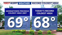
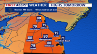
Father’s Day on Delmarva was one for the weather record books—Georgetown set a new daily cold high mark of 68°F, the third chilliest Father’s Day on record. Overcast and cool conditions linger through Monday with scattered drizzle and showers possible. A slow transition to a warmer and stormier pattern begins Tuesday, peaking Thursday with near-record heat and a risk of severe storms. Cooler, more settled weather returns for Friday and the weekend.

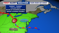
Unsettled conditions continue Sunday afternoon with continued clouds, cool temperatures, and scattered showers. A stalled front will keep the region damp through Tuesday before a warm front ushers in summerlike conditions midweek. Thursday brings a risk of severe storms followed by improving weather for the weekend.


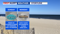
Clouds, cool temperatures, and the chance of scattered showers will dominate Delmarva’s Father’s Day forecast as a stalled front lingers near the region. Unsettled conditions will continue into early next week before a midweek warm-up sets the stage for possible severe storms Thursday. A return to sunny, dry weather is expected by Friday.


Delmarva endured a cloudy and damp Saturday with a mix of showers and hazy skies due to wildfire smoke drifting from New Jersey. The pattern of unsettled weather is expected to continue into Father’s Day and early next week, with cooler-than-normal temperatures, patchy fog, and occasional rain. A brief warm-up midweek could bring strong storms before relief arrives next weekend.


Rain and downpours return to Delmarva Sunday with a stretch of unsettled weather lasting into Tuesday as multiple waves of energy track through the region. While conditions briefly dry out by midweek, another cold front and upper-level system will bring more showers and cooler temperatures before the weekend.

Scattered showers and storms with highs in the low to mid 70s Sunday. A mild, humid weekend transitions into a wet and cooler start to the workweek across Delmarva, with periods of heavy rain and thunderstorms expected through Tuesday. A cooler, more stable pattern begins to emerge by the end of the week.

A surge of warm, humid air will usher in showers and a chance for storms across Sussex County, the Delaware Beaches, and Ocean City from late Wednesday into Thursday night, with temperatures climbing well into the 70s before a cold front cools things down.