


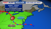


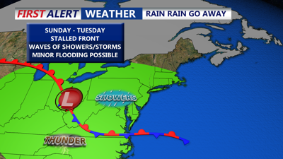
DELMARVA -- Sunday afternoon on Delmarva remained gloomy, with cool, damp air lingering across the region and highs only reaching the 60s to low 70s. A stationary front parked near the Chesapeake region continues to control the weather pattern and will do so through Tuesday, bringing unsettled conditions with periods of light rain and patchy thunderstorms.

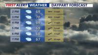
Cloudy skies, temperatures in the upper 60s to lower 70s, shower chances should hold off until late this evening into the overnight.
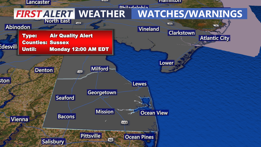
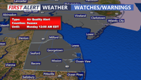
Poor air quality over Delaware continues thanks to northeast winds bringing down smoke from the Mines Sprung Wildfire burning in Wharton State Forest in Shamong Township, New Jersey. Air Quality Alerts continue through 12AM Monday, for sensitive groups.

Air Quality Alert until 12AM Monday.
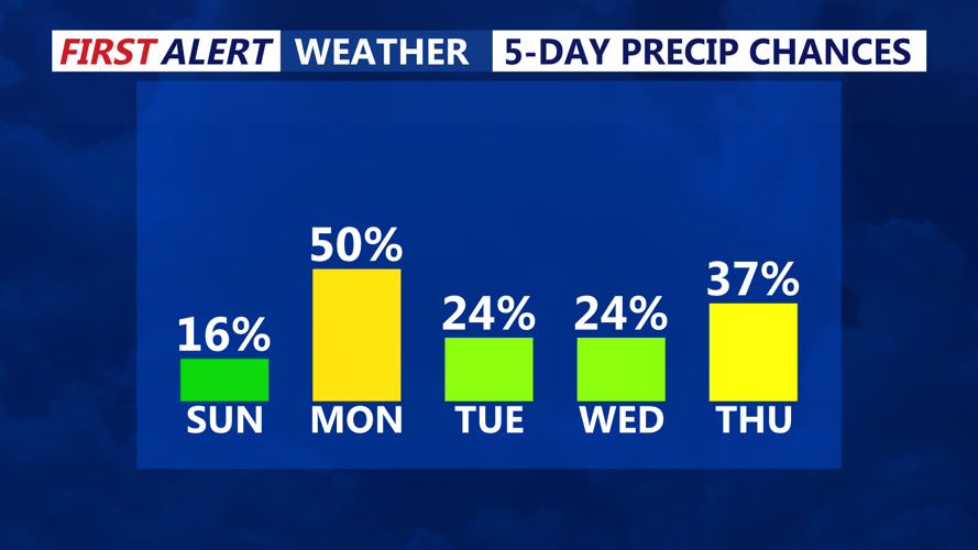
Another round of scattered showers is expected to develop later Sunday into the evening. Rain chances range between 20 to 40 percent through Monday, especially in southern parts of the region. A few isolated showers, Delmarva will see on-and-off periods of light rain through the start of the week.

Unsettled start to the the week on Delmarva with a stalled front keeping showers and storms in the forecast.
The stalled boundary will slowly shift north Monday night into Tuesday night, reaching southern Delmarva. A weak disturbance riding along the boundary may trigger additional showers and isolated thunderstorms Tuesday as it moves closer to the region. Despite the persistent rain chances, the forecast does not call for a washout, and dry breaks are likely.
Cloud cover is expected to dominate through Tuesday, limiting sunshine and keeping daytime highs in the upper 60s to low 70s on Monday, with slightly warmer conditions into the mid to upper 70s on Tuesday. Lows will remain relatively steady in the low to mid 60s throughout this period.
By Wednesday, the front will lift north as a warm front, allowing a warmer and more humid air mass to surge into the region. High pressure centered near Bermuda will take over midweek, helping push temperatures upward. Spotty afternoon thunderstorms could develop Wednesday with some instability and daytime heating.
Thursday is shaping up to be the warmest and most active day of the week. A low pressure system and deepening trough over the Great Lakes will drive a strong cold front toward Delmarva. With the area positioned in the warm sector, temperatures could climb into the low 90s. Humidity will add to the discomfort, producing heat indices above 95 degrees in spots. The potential for strong to severe thunderstorms is possible for Thursday afternoon and evening.
Conditions improve by Friday as high pressure builds back in behind the departing front, bringing sunshine and more seasonable weather into the start of next weekend.
