


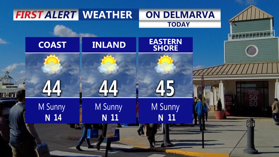


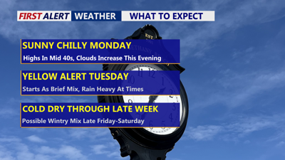
DELMARVA -- High pressure settles over Delmarva today, allowing for a brief stretch of tranquil weather before a more active pattern returns. Skies remain mostly clear through the daytime hours, with highs in the mid-40s and diminishing northwest winds as the high moves overhead. Winds will gust to 20 mph at times. High clouds may increase late in the day ahead of the next incoming system.

Mostly sunny skies highs 42-46, high clouds filter in late in the day through the evening.
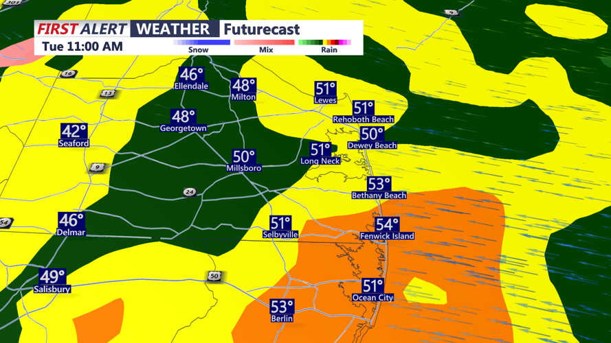
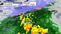
Overnight lows dip into the low 30s, but temperatures will slowly rise toward Tuesday morning as a strengthening area of low pressure lifts out of the Southeast and tracks offshore near the Delmarva coastline. Precipitation may begin as a brief wintry mix or sleet before transitioning quickly to all rain.

Rain will be heavy at times Tuesday morning-afternoon.
YELLOW ALERT DAY--The rain will be heavy at times through Tuesday morning and afternoon, with onshore flow bringing moisture off the ocean. Highs rise into the upper 40s to low 50s across the Peninsula.

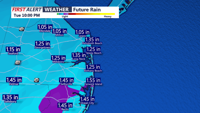
Rain/snow line pushing west of I-95, milder air flows in off the ocean, temperatures get into the 40s & 50s on Delmarva.
Rainfall totals between 0.75 and 1.25 inches are expected, and Georgetown could approach its daily rainfall record of 1.11 inches set in 1974.

Rainfall will be between 0.75" - 1.25" on Delmarva through Tuesday afternoon.
Conditions improve late Tuesday as the system pulls away, but northwest winds will increase with gusts near 30 mph. Temperatures fall into the 20s Tuesday night under clearing skies.
High pressure returns Wednesday, delivering dry and mostly sunny weather but with below-normal temperatures. Highs only reach the mid-30s to low 40s, with lows again in the 20s Wednesday night as clouds increase ahead of the next front.
A cold front moves through Delmarva Thursday into Thursday night, likely bringing the coldest night of the season so far with lows falling into the teens and wind chills in the mid-teens. Friday remains cold with highs in the upper 30s to low 40s. Another system may arrive late Friday into the weekend, but details remain uncertain; wintry precipitation is possible depending on the storm track.