


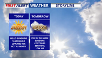
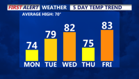
Big warm up today with 70s, then rainy and colder conditions Friday.
From
To

Strong winds and sharply colder air will sweep into Sussex County and the beach towns Tuesday, with dry but blustery conditions lasting into early Wednesday.


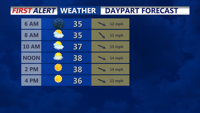
Delmarva enjoys one more day of record-setting warmth today, with inland highs in the upper 70s to low 80s and cooler readings near the water. Gusty south winds, higher humidity, and increasing clouds will build through the afternoon before a threat for a few strong to severe storms develops this evening, mainly between 6 and 10 p.m. A strong cold front moves through late tonight into Thursday morning, bringing falling temperatures, gusty northwest winds, and much colder air to end the week.

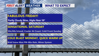
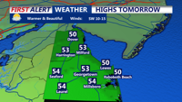
Beautiful end to a wild week, mild start to weekend, brief bout of wintry weather before big warm up
Delmarva stays quiet and seasonable today with upper 40s to low 50s, then warms quickly Saturday with inland highs near 60 (cooler at the beaches). An arctic front sweeps through late Saturday night, bringing a noticeably colder, breezy Sunday. Early next week, two separate systems could bring periods of wintry precipitation, followed by a likely transition to rain midweek. A bigger warm-up looks increasingly likely late next week.

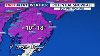
A Blizzard Warning continues for Sussex county and the rest of Delmarva until Monday evening.

After a springlike weekend in the 60s, Delmarva cools back to seasonable levels today with sunshine, before a colder, unsettled pattern brings a chance for rain and snow mid to late week.

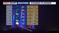
A brief warmup and gusty winds Wednesday evening will fade as colder air returns Thursday across Sussex County.

Areas of dense fog overnight, then more clouds than sun for Sunday and chilly. Then much colder early next week.

DELMARVA -- High pressure shifts to the south and east of Delmarva on Monday afternoon, setting up a return flow that will help push temperatu…

Sussex County and Delmarva beaches brace for gusty winds Wednesday as a cold front sweeps through, followed by another system bringing rain and potential wintry precipitation later in the week.