


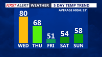


DELMARVA -- Today marks the final day of unseasonably warm weather across Delmarva, with record-setting warmth continuing across the peninsula. Inland areas will climb into the upper 70s to low 80s, while communities closer to the water stay cooler in the 60s and 70s. Clouds will increase this afternoon, and humidity will continue to rise as dew points push into the 50s and 60s.

Warmest temperatures will be early Thursday, temperatures will crash through the day as a cold front pushes through.
Southerly winds will strengthen through the day as low pressure deepens over the eastern Great Lakes while high pressure remains anchored over the western Atlantic. That setup will tighten the pressure gradient across the region, leading to wind gusts of 20 to 35 mph this afternoon.
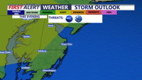
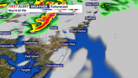
Attention then turns to the potential for severe weather early this evening. A pre-frontal trough may trigger strong to severe thunderstorms, with the greatest concern focused on northern and western parts of Delmarva. The Storm Prediction Center places part of the peninsula under a marginal risk, with western sections in a slight risk.

Marginal to Slight risk of severe storms this evening, damaging winds 60MPH+, hail and isolated tornado possible. Best chance to see a storm is northern and western portions of the peninsula.
If storms do develop, the main threats would include damaging wind gusts over 60 mph, large hail, and an isolated tornado. Residents should stay weather aware between 6 and 10 p.m., even though the overall threat remains limited.

Strong to severe storms are possible this evening, best chance for storms would be northern portions of the peninsula.
Temperatures tonight will stay very mild, holding in the 60s and 70s ahead of the approaching cold front. That front will sweep across the Mid-Atlantic late tonight into Thursday morning. Most of the showers with the front look to be post-frontal, which should keep the risk for additional severe weather low. Once the front moves through, temperatures will quickly tumble toward daybreak Thursday.
Thursday will bring a dramatic change across Delmarva. Mild readings early in the day will fall through the 50s and into the 40s by afternoon as strong cold air advection spreads in from west to east. A few showers may linger behind the front, and while some guidance hints at a brief change to wet snow in a few spots, no accumulation is expected with temperatures remaining above freezing and drier air arriving quickly.
The bigger impact Thursday will be the wind and the colder feel. Gusty northwest winds of 30 to 40 mph are expected through about mid-afternoon before gradually easing in the evening. Those winds, combined with falling temperatures, will make it feel sharply colder across the peninsula. By Thursday night, most of Delmarva will drop into the upper 20s to low 30s by early Friday morning.
Looking ahead, the weekend looks pretty nice, Saturday on the cooler side highs in the 50s, cooler at the beaches. Sunday upper 50s to low 60s under mostly cloudy skies. Another strong cold front is expected to move through Monday. Rain is likely to develop Sunday night into Monday as low pressure tracks just north of the region. As colder air rushes in later Monday, there could be a brief transition to snow before precipitation ends, though that will depend on the timing of the system and how much moisture remains in place. Even beyond that, a surge of colder air may settle over Delmarva into Tuesday (St. Patrick's Day), with highs struggling to reach 40 degrees in many locations.