


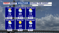
A warm up kicks in today with a strong southwesterly flow. Temperatures top out in the mid 70s, with cooler conditions at the coast.
From
To


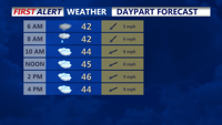
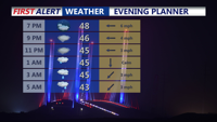
Skies clear overnight, with a chilly breeze and temperatures falling into the low to mid 40s by Sunday morning.


DELMARVA - This morning, a backdoor front will slide southwestward into the region, setting up a northeast to east low-level flow. This will b…

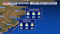
The summer-like heat is coming to an end, with a cooler weekend in store, along with Sunday showers.

Lingering rain early Thursday should give way to cooler, variable conditions before a warm front brings a chance of light rain and patchy fog late Thursday night into early Friday.

Watch for areas of fog out the door this morning, along with drizzle and chilly temperatures.

Heading into tonight, expect spotty showers and areas of drizzle to develop, especially farther north on Delmarva.


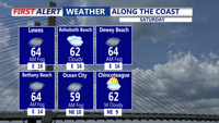
Sussex County will start Saturday mild and dry with highs in the 50s, then turn cooler overnight as a cold front pushes in, with a chance of spotty showers by Sunday morning.

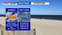
Sunday brings warm, humid conditions with rip current dangers along the coast. A cold front early in the week will usher in cooler, drier air, bringing a September-like feel as Labor Day weekend approaches.

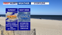
Delmarva can expect a warm, humid Sunday followed by a shift to cooler, drier air early in the week, bringing a taste of September weather just in time for the end of August.