


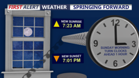
Remember to set your clocks ahead one hour tonight as we start Daylight Saving Time.
From
To


The low clouds and fog have burned off for inland areas with temperatures in the 60s this afternoon, but only 40s at the coast.


Delmarva stays locked under clouds today as a backdoor cold front keeps temperatures chilly, especially near the beaches. Fog and drizzle develop tonight, then milder air builds in this weekend with partial clearing Saturday afternoon, a chance for showers overnight Saturday into Sunday, and much warmer temperatures arriving early next week.

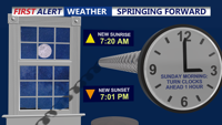
A cold and clear Saturday night will bring temperatures down into the 20s across Delmarva, but warmer days are ahead. Don't forget to set those clocks ahead an hour tonight. Sunday remains breezy with highs in the 50s, followed by a gradual warming trend through the week. By midweek, highs will reach the 60s, with temperatures possibly touching the low 70s by next Saturday.

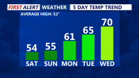
Delmarva will enjoy sunshine and seasonable temperatures this weekend, with highs in the low to mid-50s. Saturday night will be clear and chilly, with lows in the upper 20s to low 30s. Don't forget to set clocks forward an hour for daylight saving time and check smoke detectors. A warming trend begins Monday, bringing highs in the 60s and possibly reaching the low 70s by midweek.

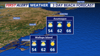
After a blustery Saturday, Sussex County’s beach towns will see improving conditions with milder temperatures Sunday into early Monday. The region remains dry, but don’t forget to set your clocks ahead Saturday night as daylight saving time begins.

A weakening disturbance will move through Sussex County late Friday into early Saturday, bringing gusty winds before a gradual warmup Sunday and Monday. Don’t forget to set your clocks ahead an hour Saturday night as daylight saving time begins.


DELMARVA- Spring is almost here, and so are longer days! Daylight saving time kicks in this weekend, bringing later sunsets and plenty of ways…

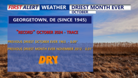
October brought record-breaking dry conditions to Delmarva, with Georgetown marking 35 consecutive days without measurable rainfall. High pressure will dominate through early next week, maintaining clear skies and cool nights, but temperatures are expected to warm into the 70s by Tuesday. A weak cold front arrives midweek, offering a slight chance of rain, before high pressure returns to end the week.