




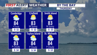
Sussex County will see a warm and increasingly humid Thursday before a cold front brings showers and a few possible thunderstorms Thursday night.
From
To

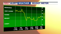
Sussex County will turn hot and humid Thursday, with another round of strong to severe thunderstorms possible later in the day.


A pleasant and quiet rest of the weekend, building heat builds next week.


The heavy rain threat continues this afternoon and evening. Some isolated flash flooding is possible.


A beautiful Thursday is ahead across Delmarva with hazy sunshine, highs in the upper 80s to low 90s and a refreshing sea breeze developing at the beaches. A cold front will continue pushing south through Friday, opening the door to cooler and less humid weather for Saturday and the first half of Sunday. Showers and thunderstorms return to the forecast Sunday afternoon into Monday, while spotty minor tidal flooding is possible during Thursday evening’s high tide along portions of the Delaware coast and Delaware Bay.


After morning rain, Delmarva will enjoy clearing skies, lower humidity, and comfortable temperatures to end Friday. The weekend looks mostly sunny and pleasant, with seasonable warmth and low humidity for outdoor plans and Father’s Day. A more unsettled pattern returns Monday with widespread rain and some thunderstorms possible.


A few showers may linger early Friday in Sussex County before cooler, less humid weather takes hold into early Saturday.


Delmarva will enjoy a mostly sunny and pleasant Friday with highs in the upper 60s to low 70s before a warming trend takes hold this weekend. Temperatures will climb into the upper 70s and low 80s Saturday, then surge into the mid 80s to low 90s from Sunday through the middle of next week. Mostly dry weather is expected through the next several days, though isolated showers or storms are possible Sunday and a better chance of showers and thunderstorms arrives late Wednesday into Thursday as a cold front brings temperatures closer to normal.


Delmarva will enjoy a pleasant Friday with highs ranging from the upper 50s and low 60s along the coast to the mid and upper 60s inland and around the Mid-Shore. Clouds increase late today as weak low pressure approaches, bringing only a brief shower or sprinkle overnight. The weekend starts mostly cloudy with a slight coastal rain chance Saturday, then turns sunnier and breezy Sunday before a major warmup sends temperatures into the 70s and near 80 by Tuesday.


High pressure will keep Sussex County mostly dry through Thursday, with a cold front bringing cooler temperatures and only spotty shower chances into Friday.