


The stretch of dangerous heat and humidity continues, with a continued risk for strong to severe thunderstorms.
From
To

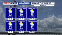
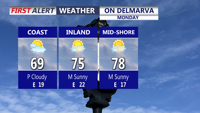
High pressure is building in from the north, bringing cooler and breezy weather for Monday.

Mainly clear and cooler overnight with lows in the 60s.


Crowds flocked to Delaware beaches Monday as an early-season heat wave pushed inland temperatures into the 90s across Delmarva.

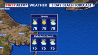
Delmarva will see another warm, humid day Wednesday with highs in the low to mid-80s and a high rip current risk along the coast. Can't rule out an isolated shower or storm this evening. Thursday is a Yellow Alert Day, with the potential for severe storms bringing damaging winds as a cold front approaches the region.

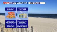
A strong high-pressure system building over the Mid-Atlantic will bring dangerously hot and humid conditions to Delmarva starting Monday. Heat index values are forecast to soar between 100 to 110 degrees through Tuesday, with only slight relief expected by midweek. Heat Advisories remain in effect, with an Extreme Heat Watch issued for parts of southern Delmarva. Rain chances and cooler temperatures return by late week.


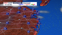
Low pressure moving from Pennsylvania toward New England will drag a strong cold front through Delmarva by early Monday morning, ushering in much cooler temperatures, gusty winds, and partly cloudy skies.

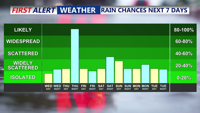
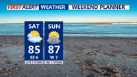
Expect a mild and pleasant weekend across Delmarva with sunny skies and comfortable humidity levels. Highs will range from the upper 70s to upper 80s on Saturday, slightly cooler on Sunday and Monday. Light winds and occasional morning fog are anticipated. Midweek, there is a potential for increased cloudiness and shower chances due to possible tropical development off the southeast coast.

A primary cold front will approach the Delmarva Peninsula on Saturday, bringing warmer and muggier conditions by the afternoon as the flow turns southerly. Expect high temperatures in the low to mid-80s with mainly dry weather during the day, but showers and thunderstorms are likely after 8 PM as the front moves in. Additional unsettled weather is anticipated from Sunday with a marginal risk for severe storms. High pressure will bring drier conditions for the first half of the upcoming week.


In Milford, the "Power Saver Hours" are set from 3 p.m. to 7 p.m.. DEC's similar "Beat the Peak" initiative is set to go from 4 p.m. to 6 p.m.