As we say goodbye to 2025, it is time to reflect on all of the events that impacted our community. This year in review offers a look back at some of the most impactful and interesting stories across Delmarva.
As we say goodbye to 2025, it is time to reflect on all of the events that impacted our community. This year in review offers a look back at some of the most impactful and interesting stories across Delmarva.

As we say goodbye to 2025, it is time to reflect on all of the events that impacted our community. This year in review offers a look back at some of the most impactful and interesting stories across Delmarva.
The Cape May–Lewes Ferry has canceled all departures scheduled for Sunday, Oct. 12 due to the approaching coastal storm forecast to bring heavy rain, strong winds, and rough seas to the region.

Here are some of the stories that captured Delmarva's attention this week.

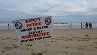
After several days of limited access and safety concerns, Ocean City officials say beach activities are returning to normal, with a few precautions still in place.
Ocean City continues swimming restrictions amid dangerous rip currents according to the beach patrol.
Taking a look at the top stories across Delmarva this week.
Delmarva faces moderate coastal flooding Friday evening as we deal with residual impacts of Hurricane Erin, with warnings in effect through early Saturday. Skies will clear overnight with lows in the 50s inland and low 60s near the coast. Saturday brings sunshine and highs in the low to mid 80s, followed by rising humidity ahead of a cold front Sunday into Monday that could spark scattered showers and thunderstorms. Cooler, drier air returns by midweek, with highs in the 70s and lows in the 50s.

Despite beach closures due to what DRNEC calls unsafe conditions, some people at Cape Henlopen State Park were still seen entering the water on Friday.
Hurricane Erin caused 10-14 feet of erosion at the north side of the Indian River Inlet and forced an overnight closure of Route 1 due to bayside flooding. Officials say dunes helped protect infrastructure, but damage along the coast remains visible.