


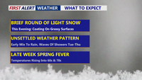
Arctic high pressure keeps Delmarva cold through Tuesday, with clouds increasing and a brief window for light snow late today into this evening. Any accumulation should be minor and mainly on grassy or elevated surfaces, with roads staying mostly wet as snow melts. Overnight, snow changes to sleet or a wintry mix, then turns to light rain by Tuesday morning. After a damp Tuesday, temperatures surge mid-week into the weekend, running 10 to 20 degrees above normal with occasional showers and even a chance for a rumble of thunder Thursday night.
From
To


Light snow late Friday night is expected to be followed by high winds and life-threatening wind chills Saturday into early Sunday from Delaware’s beaches through Ocean City.

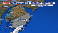
Light snow is expected to arrive late Friday in Sussex County, with minor accumulation possible before tapering to scattered snow showers or a brief squall early Saturday as colder air moves in.

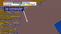
Sussex County is expected to stay mostly calm through Friday evening, with light snow developing late and a much more dangerous wind-and-cold outbreak slated for the weekend.

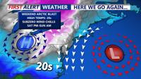
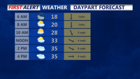
Colder-than-normal temperatures have settled across Delmarva, with highs ranging from the mid-30s to low 40s. The chill deepens by Thursday and into the weekend, as an arctic cold front approaches. While light snow is possible Friday, more impactful snow squalls and dangerously cold wind chills are expected Friday night into Saturday. Gusty winds behind the front may reach 50 mph, especially near the coast.

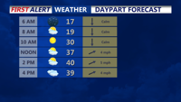
Temperatures above freezing much of the week with light snow from clipper systems.

Temperatures finally creeping above the freezing mark today, with readings above freezing for much of the week ahead.

It’s Groundhog Day, and Punxsutawney Phil is calling for six more weeks of winter—but the COASTTV First Alert Weather team is already ahead of him, tracking more arctic air for Delmarva even after a short-lived warm-up. We’ll squeeze out some milder temperatures Tuesday, but a pair of clipper systems could bring light snow chances midweek and again Friday night, followed by another blast of bitter cold this weekend.

The main effects from the powerful off shore storm will be the wind, dangerous wind chills, and minor tidal flooding.

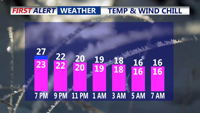
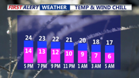
This morning wind chills could fall as low as 3 to 6 below zero, especially in more exposed locations.