


A strong low-pressure system will continue to track through the region Thursday night into Friday, bringing gusty west winds and cooler temperatures to Sussex County, with high pressure returning this weekend.
From
To

A coastal low-pressure system is expected to bring rain, gusty winds, and cooler temperatures to Sussex County's beach communities from late Thursday through Friday.

Delmarva will experience a series of weather changes this week beginning Saturday night, as a cold front ushers in chilly overnight lows. High pressure brings brief clearing Sunday, followed by multiple low-pressure systems bringing rounds of rain through midweek. A gradual warm-up returns by the weekend.

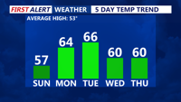
Delmarva will experience clear and chilly conditions Sunday night, with lows in the mid-30s. A warming trend kicks off Monday, with highs reaching the low to mid-60s under mostly sunny skies. A stronger low will move in Monday night into Tuesday, lifting a warm front northward. By Tuesday, temperatures will climb further into the 60s, though a backdoor cold front could bring midweek uncertainty. A high-pressure system will briefly cool things down Wednesday before warmer air returns later in the week. By Saturday, highs could push into the upper 60s to low 70s.


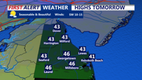
A high-pressure system will keep Sussex County and Ocean City dry but cold through Friday, before a strengthening low-pressure system brings increasing clouds and the potential for rain late Saturday.


A winter storm is set to impact Delmarva this afternoon as a low-pressure system moves up the coast, bringing periods of heavy snowfall through tonight. Snow accumulation is expected to range from 5 to 7 inches across much of the region, with localized areas potentially seeing higher totals. A Winter Storm Warning remains in effect until 7 a.m. Wednesday.

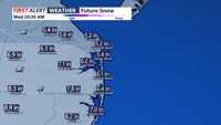
A winter storm will bring heavy snow, strong winds, and hazardous travel conditions to Sussex County and Ocean City from Tuesday afternoon through early Wednesday, followed by a wintry mix before tapering off late Wednesday night.

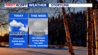
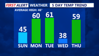
Delmarva will see a dry but breezy Super Bowl Sunday, with highs reaching the mid to upper 40s. A period of calmer weather follows Monday before a series of storm systems bring accumulating snow and mixed precipitation to the region midweek. High pressure will return to close out the week.

Seasonable conditions today, with highs in the mid-40s and increasing clouds as a warm front approaches. Monday brings much milder temperatures, with the upper 50s to low 60s. A cold front moves through late Monday night, keeping Tuesday’s highs similar to Monday but occurring earlier in the day. By midweek, a more active pattern develops, with a low-pressure system bringing widespread precipitation Wednesday through Thursday night.

Sussex County can expect a cold front to bring gusty winds and showers Tuesday, followed by another cold front late Wednesday into Thursday, delivering colder temperatures and clearer skies.