


DELMARVA - Sussex County residents should prepare for a mix of weather conditions late Monday night through Tuesday and into midweek. A low-pressure system moving across northeastern Canada will drag a cold front through the region on Tuesday, followed by a second front Wednesday night into Thursday, according to meteorologists.
Monday night will begin with clear skies before transitioning to partly cloudy conditions as high clouds move in. Winds will decrease to 5-10 mph overnight, and temperatures will drop to lows between 25 and 30 degrees.
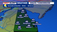
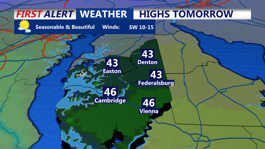
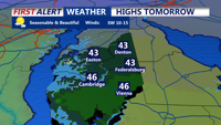
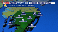
Tuesday’s weather will bring an arctic cold front through the region. While limited moisture will reduce widespread precipitation, isolated snow showers or brief snow squalls could occur. Any snowfall accumulation is expected to be minimal, with less than half an inch possible in localized areas. Sussex County temperatures will reach highs in the low 40s by midday but will drop as gusty northwest winds of 20-30 mph set in during the afternoon.
Looking ahead to Tuesday night, a weak surface ridge will bring calmer weather early on, with lows initially dropping into the 20s before temperatures slightly rise overnight. Another low-pressure system will pass to the north on Wednesday, creating gusty west winds of 25-35 mph. Highs will reach the low to mid-50s inland and 40s along the beaches.
Late Wednesday into Thursday, another cold front is expected, bringing a chance of brief snow showers or squalls, especially in northern areas of the Delmarva Peninsula. Wind gusts during these squalls could reach up to 50 mph. By Thursday, high pressure will return, delivering sunshine and colder temperatures.